IMAGES TAKEN NEAR TO
Greenside, RYTON, NE40 4ST
Introduction
This page details the photographs taken nearby to NE40 4ST by members of the Geograph project.
The Geograph project started in 2005 with the aim of publishing, organising and preserving representative images for every square kilometre of Great Britain, Ireland and the Isle of Man.

There are currently over 7.5m images from over14,400 individuals and you can help contribute to the project by visiting https://www.geograph.org.uk
Image Map
Images are licensed for reuse under creativecommons.org/licenses/by-sa/2.0
Notes
- Clicking on the map will re-center to the selected point.
- The higher the marker number, the further away the image location is from the centre of the postcode.
Image Listing (6 Images Found)
Images are licensed for reuse under creativecommons.org/licenses/by-sa/2.0
Image
Details
Distance
2
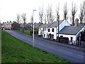
Alma Terrace, Greenside
Alma Terrace runs between Lead Road and Folly Road.
Image: © Andrew Curtis
Taken: 24 Feb 2012
0.07 miles
3
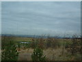
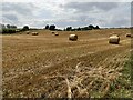
Folly Farm
Land to the south of Folly Farm. It's a lot nicer to look at than landfill.
Image: © Steve McShane
Taken: 28 Jan 2006
0.19 miles
6
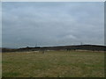
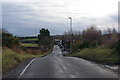
Burnhills Landfill Site
A fairly nondescript photo of the south-western edge of the landfill site, without getting too close to these unsightly areas... This shot is taken from fields at the end of Burnhills Lane (itself a horrible track which has been used as a dumping ground for the usual things - old fridges, cookers etc...). Apart from the Folly landhill site, there's not much that this square has to offer.
Image: © Steve McShane
Taken: 28 Jan 2006
0.22 miles