IMAGES TAKEN NEAR TO
Crown Terrace, RYTON, NE40 4QZ
Introduction
This page details the photographs taken nearby to Crown Terrace, NE40 4QZ by members of the Geograph project.
The Geograph project started in 2005 with the aim of publishing, organising and preserving representative images for every square kilometre of Great Britain, Ireland and the Isle of Man.

There are currently over 7.5m images from over14,400 individuals and you can help contribute to the project by visiting https://www.geograph.org.uk
Image Map (Loading...)


Getting Data...Please wait
Leaflet Map data © OpenStreetMap
Images are licensed for reuse under creativecommons.org/licenses/by-sa/2.0
Notes
- Clicking on the map will re-center to the selected point.
- The higher the marker number, the further away the image location is from the centre of the postcode.
Image Listing (3 Images Found)
Images are licensed for reuse under creativecommons.org/licenses/by-sa/2.0
Image
Details
Distance
1
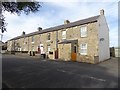
Crown Terrace, Greenside
On Lead Road.
Image: © Oliver Dixon
Taken: 23 Sep 2016
0.02 miles
2
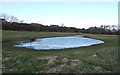
Pond, Greenside
The trees before the houses mark the line of a disused mineral railway which ran parallel to the Lead Road. The railway ran from Greenside Colliery to Stargate Pit and Addison Colliery on the Newcastle and Carlisle line. Part of its line is now used as a footpath.
Image: © Andrew Curtis
Taken: 24 Feb 2012
0.19 miles
3
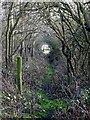
Tree tunnel near Greenside
The 'tunnel' is the route of an overgrown footpath south of the High Folly area of Greenside.
Image: © Andrew Curtis
Taken: 24 Feb 2012
0.24 miles