IMAGES TAKEN NEAR TO
Greenside, RYTON, NE40 4AB
Introduction
This page details the photographs taken nearby to NE40 4AB by members of the Geograph project.
The Geograph project started in 2005 with the aim of publishing, organising and preserving representative images for every square kilometre of Great Britain, Ireland and the Isle of Man.

There are currently over 7.5m images from over14,400 individuals and you can help contribute to the project by visiting https://www.geograph.org.uk
Image Map (Loading...)


Getting Data...Please wait
Leaflet Map data © OpenStreetMap
Images are licensed for reuse under creativecommons.org/licenses/by-sa/2.0
Notes
- Clicking on the map will re-center to the selected point.
- The higher the marker number, the further away the image location is from the centre of the postcode.
Image Listing (22 Images Found)
Images are licensed for reuse under creativecommons.org/licenses/by-sa/2.0
Image
Details
Distance
1
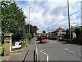
Looking along Woodside Lane
View north along the road to Ryton from Lead Road in Greenside. More modern housing here compared to the mainly 19th and early 20th century buildings in the village centre.
Image: © Robert Graham
Taken: 4 Jul 2022
0.06 miles
2
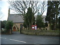
St John's
The Church of England parish of St John's in Greenside, built in the first half of the 19th Century.
Image: © Steve McShane
Taken: 28 Jan 2006
0.10 miles
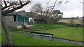
3
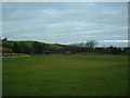
Greenside Cricket Club
Hmm, quintessentially English? Drizzle in the air, no play today... mind you, it is January.
Image: © Steve McShane
Taken: 28 Jan 2006
0.11 miles
5
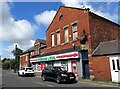
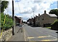
Village Post Office, Greenside
On Lead Road, the main street through Greenside.
Image: © Robert Graham
Taken: 4 Jul 2022
0.14 miles
6
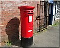
Post box in Greenside
Outside the village Post Office on Lead Road.
Image: © Robert Graham
Taken: 4 Jul 2022
0.14 miles
7
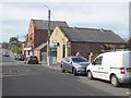
Shops on Lead Road, Greenside
A Spar mini-market and "Fishnets" - a fish and chips shop.
Image: © Oliver Dixon
Taken: 23 Sep 2016
0.14 miles
8
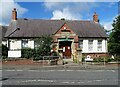
Greenside Community Centre
As the inscription shows, this was originally Greenside Colliery Institute built in 1925. Renovated and converted to its present use in 2017. Stands on Woodside Lane in the village centre.
Image: © Robert Graham
Taken: 4 Jul 2022
0.14 miles
9
Looking east along the main street in Greenside
A view along Lead Road, past the junction with Woodside Lane, on the left.
Image: © Robert Graham
Taken: 4 Jul 2022
0.16 miles
10
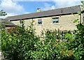
The Steadings, Greenside
This stands on Lead Road, the village main street. Although obviously this has been converted to residential, it seems to be a genuine early 19th farm building. It dates to the time when this was a mainly agricultural village.
Image: © Robert Graham
Taken: 4 Jul 2022
0.16 miles