IMAGES TAKEN NEAR TO
East View, RYTON, NE40 3BF
Introduction
This page details the photographs taken nearby to East View, NE40 3BF by members of the Geograph project.
The Geograph project started in 2005 with the aim of publishing, organising and preserving representative images for every square kilometre of Great Britain, Ireland and the Isle of Man.

There are currently over 7.5m images from over14,400 individuals and you can help contribute to the project by visiting https://www.geograph.org.uk
Image Map
Images are licensed for reuse under creativecommons.org/licenses/by-sa/2.0
Notes
- Clicking on the map will re-center to the selected point.
- The higher the marker number, the further away the image location is from the centre of the postcode.
Image Listing (38 Images Found)
Images are licensed for reuse under creativecommons.org/licenses/by-sa/2.0
Image
Details
Distance
1
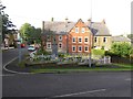
War Memorial, Clara Vale
On Stannerford Road.
Image: © Oliver Dixon
Taken: 23 Sep 2016
0.00 miles
2
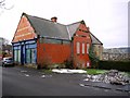
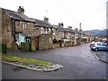
Former Co-operative Building, Clara Vale
Large building in red brick, now empty leaving no shop in the village. Behind, to the right, is the long terrace, East View, built in stone. These houses are known locally as "sinkers' cottages" built for the miners who initially sunk the pit shafts. Later terraces in the village are built of local brick.
Image: © Andrew Curtis
Taken: 30 Dec 2010
0.00 miles
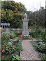
4
War Memorial, Clara Vale
The memorial stands in a prominent position at the east side of the [former] Co-operative Stores, visible on the right, within the triangle of roads where Stannerford Road enters the village from the south Image Edington Cottages are behind with the Methodist Chapel and Hall visible in the distance.
The memorial is a square block of Aberdeen granite, standing ten feet high, surmounted by a bowl and urn. One face is inscribed with fifty six names of former colliery employees who fell in the Great War. The site was given as a gift from the Stella Coal Company who also agreed to erect the surrounding wall and railings. It was unveiled on Saturday, 22nd of October 1921. The site was regarded as being in an ideal position, with the wood in the background (Bog Wood) and westbound travellers on the railway being given an unrestricted view of the memorial. Following the end of the 1939-45 conflict, two additional names of men from the village were added to the memorial. The fewer names reflect the fact that mining was a reserved occupation, essential to the national war effort, during this conflict.
Information from Ryton & District War Memorials Project: http://www.rytonwarmemorials.org.uk/sub_memorial_section.php?page=clara_vale_war_memorial
Image: © Andrew Curtis
Taken: 30 Dec 2010
0.01 miles
5
West View, Clara Vale
The rear of East View, the similar terrace on the right is shown in this old photo http://isee.gateshead.gov.uk/detail.php?t=objects&type=all&f=&s=clara+vale&record=10
Apart from a proliferation of outbuildings and extensions there has been little change.
Image: © Andrew Curtis
Taken: 30 Dec 2010
0.03 miles
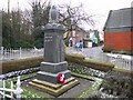
6
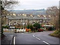
Clara Vale
The entrance to the village from Stannerford Road. The War Memorial is on the left behind the sign to the Recreation Ground Image
The terraced houses in East View are shown in this old photo http://isee.gateshead.gov.uk/detail.php?t=objects&type=all&f=&s=clara+vale&record=8
Image: © Andrew Curtis
Taken: 30 Dec 2010
0.03 miles
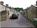
7
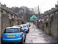
Back lane between East and West View, Clara Vale
The lane serves the rear of the long stone built terraces, an early part of the model colliery village of Clara Vale. Long gardens were supplied on the other side of the houses. The Methodist Church Hall can be seen at the far end of the lane Image
Tyne and Wear HER (12048): Clara Vale, East and West View http://www.twsitelines.info
Image: © Andrew Curtis
Taken: 30 Dec 2010
0.04 miles
8
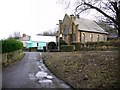
Church Hall and Methodist Church, Clara Vale
View from Edington Gardens. There is another photo here Image
Image: © Andrew Curtis
Taken: 30 Dec 2010
0.04 miles
9
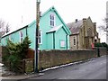
Church Hall and Methodist Church, Clara Vale
An inscription above the Church porch is dated 1908.
Tyne and Wear HER (12045): Clara Vale, Methodist Church http://www.twsitelines.info
The hall, a former Methodist Sunday School is on Gateshead Council's Local List. It is built in corrugated iron with a porch and rectangular hood-moulded window openings and painted a bright green.
Tyne and Wear HER (7471): Clara Vale, Methodist Church Hall http://www.twsitelines.info
The hall (institute) is shown in this photo from 1900 before the church was built http://isee.gateshead.gov.uk/detail.php?t=objects&type=all&f=&s=clara+vale&record=4
Image: © Andrew Curtis
Taken: 30 Dec 2010
0.04 miles
10
Back Street, Clara Vale
The Methodist Church Hall, painted light green, at the top of the street.
Image: © Russel Wills
Taken: 8 Aug 2013
0.04 miles