War Memorial, Clara Vale
Introduction
The photograph on this page of War Memorial, Clara Vale by Andrew Curtis as part of the Geograph project.
The Geograph project started in 2005 with the aim of publishing, organising and preserving representative images for every square kilometre of Great Britain, Ireland and the Isle of Man.

There are currently over 7.5m images from over 14,400 individuals and you can help contribute to the project by visiting https://www.geograph.org.uk
War Memorial, Clara Vale
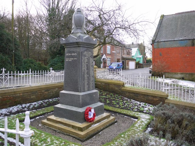
Image: © Andrew Curtis Taken: 30 Dec 2010
The memorial stands in a prominent position at the east side of the [former] Co-operative Stores, visible on the right, within the triangle of roads where Stannerford Road enters the village from the south Image Edington Cottages are behind with the Methodist Chapel and Hall visible in the distance. The memorial is a square block of Aberdeen granite, standing ten feet high, surmounted by a bowl and urn. One face is inscribed with fifty six names of former colliery employees who fell in the Great War. The site was given as a gift from the Stella Coal Company who also agreed to erect the surrounding wall and railings. It was unveiled on Saturday, 22nd of October 1921. The site was regarded as being in an ideal position, with the wood in the background (Bog Wood) and westbound travellers on the railway being given an unrestricted view of the memorial. Following the end of the 1939-45 conflict, two additional names of men from the village were added to the memorial. The fewer names reflect the fact that mining was a reserved occupation, essential to the national war effort, during this conflict. Information from Ryton & District War Memorials Project: http://www.rytonwarmemorials.org.uk/sub_memorial_section.php?page=clara_vale_war_memorial
Images are licensed for reuse under creativecommons.org/licenses/by-sa/2.0
Image Location
Latitude
54.978529
Longitude
-1.791859