IMAGES TAKEN NEAR TO
ROWLANDS GILL, NE39 1NP
Introduction
This page details the photographs taken nearby to NE39 1NP by members of the Geograph project.
The Geograph project started in 2005 with the aim of publishing, organising and preserving representative images for every square kilometre of Great Britain, Ireland and the Isle of Man.

There are currently over 7.5m images from over14,400 individuals and you can help contribute to the project by visiting https://www.geograph.org.uk
Image Map
Images are licensed for reuse under creativecommons.org/licenses/by-sa/2.0
Notes
- Clicking on the map will re-center to the selected point.
- The higher the marker number, the further away the image location is from the centre of the postcode.
Image Listing (13 Images Found)
Images are licensed for reuse under creativecommons.org/licenses/by-sa/2.0
Image
Details
Distance
1
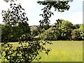
Hayfield at Low Friarside Farm
Field with a good display of Buttercups beside the Derwent Walk Railway Path. The farm can just be glimpsed through the trees.
Image: © Robert Graham
Taken: 6 Jun 2014
0.02 miles
2
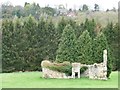
Friarside Chapel
Grade II* listed and a schedued ancient monument. Here's what it looked like in 1961 http://isee.gateshead.gov.uk/detail.php?t=objects&type=all&f=&s=friarside&record=0
Image: © Christine Johnstone
Taken: 12 Apr 2012
0.07 miles
3
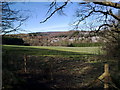
Looking over the woods
View of the woods from the Derwent Walk in early spring with Rowlands Gill in the distance.
Image: © Robert Graham
Taken: 22 Mar 2011
0.08 miles
4

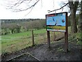
The view from the Red Kite View Point
Farmland at Friarside, in the Derwent Valley. The grassy field has been partially mown [in April], presumably to support the red kites.
Image: © Christine Johnstone
Taken: 12 Apr 2012
0.11 miles
5
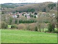
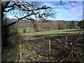
Farmland, south side of Derwent Valley
Seen from the Derwent Walk, a former railway line.
Image: © Christine Johnstone
Taken: 12 Apr 2012
0.11 miles
6
Red Kite View Point, Low Friarside
On the Derwent Walk [also the Red Kite Trail], overlooking the Derwent Valley.
Image: © Christine Johnstone
Taken: 12 Apr 2012
0.12 miles
7
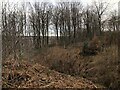
Woodland scene from the Derwent Walk
Looking North over the woods in early spring
Image: © Robert Graham
Taken: 22 Mar 2011
0.16 miles
8
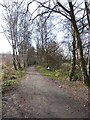
Derwent Path at Rowlands Gill
Constructed in 1867 and running from Swalwell on the River Tyne up to Consett, the Derwent Valley railway finally closed in 1963. The footpath on the line of the old railway has been converted into a cycleway and forms part of National Cycle Network route 14.
Image: © Oliver Dixon
Taken: 28 Feb 2014
0.20 miles
10
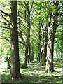
Another Sycamore Lined Walkway
Path through the churchyard for the Church of St James which is situated on both sides of the B6310.
Image: © Christine Westerback
Taken: 28 May 2006
0.24 miles