IMAGES TAKEN NEAR TO
Mapledene, WASHINGTON, NE38 8SP
Introduction
This page details the photographs taken nearby to Mapledene, NE38 8SP by members of the Geograph project.
The Geograph project started in 2005 with the aim of publishing, organising and preserving representative images for every square kilometre of Great Britain, Ireland and the Isle of Man.

There are currently over 7.5m images from over14,400 individuals and you can help contribute to the project by visiting https://www.geograph.org.uk
Image Map
Images are licensed for reuse under creativecommons.org/licenses/by-sa/2.0
Notes
- Clicking on the map will re-center to the selected point.
- The higher the marker number, the further away the image location is from the centre of the postcode.
Image Listing (14 Images Found)
Images are licensed for reuse under creativecommons.org/licenses/by-sa/2.0
Image
Details
Distance
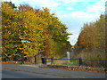
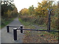
3
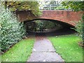
Consett and Sunderland Railway Path
A former colliery railway crosses Biddick Lane. The trackbed is now a cycle path, part of the very popular Coast to Coast route.
Image: © Richard Webb
Taken: 18 Jun 2013
0.14 miles
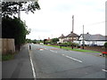
4
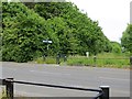
Crossing on the Consett and Sunderland railway path
The Consett and Sunderland Railway Path forms part of the world-famous C2C cycle route. Here it crosses Biddick Land in Washington, and barriers have been erected to slow cyclists down.
The National Cycle Network is marked at intervals by specially designed mileposts donated to the project by the Royal Bank of Scotland. There are four designs - one each by an Englishman, a Welshman, a Scotsman and an Irishman. The example seen here on the left is an "English" one, entitled "the Fossil Tree" and designed by John Mills. The arms indicate Chester-le-Street 3.5 miles and Consett 15 miles to the left and Wildfowl Trust 2 miles and Roker Pier 9 miles to the right.
Image: © Oliver Dixon
Taken: 19 Jun 2015
0.14 miles
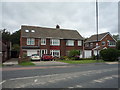
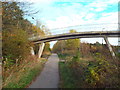
5
C2C cycle route, Washington
Here, the C2C cycle route follows the route of a dismantled railway line through Washington.
Image: © Malc McDonald
Taken: 29 Oct 2016
0.14 miles
8
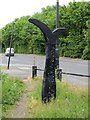
Millennium milepost , Washington
This one is on Biddick Lane where route 7 crosses on an old colliery railway trackbed.
Image: © Richard Webb
Taken: 18 Jun 2013
0.15 miles
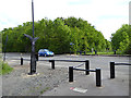
9
C2C cycle route, Washington
Here, the C2C cycle route follows the route of a dismantled railway line through Washington.
To the right of the image is a National Cycle Network milepost.
Image: © Malc McDonald
Taken: 29 Oct 2016
0.15 miles
10
Cycle path through Washington
This cycle path, which follows the route of a dismantled railway through Washington, forms part of the C2C long-distance cycle route.
Image: © Malc McDonald
Taken: 29 Oct 2016
0.15 miles