IMAGES TAKEN NEAR TO
Waterside Gardens, WASHINGTON, NE38 8AS
Introduction
This page details the photographs taken nearby to Waterside Gardens, NE38 8AS by members of the Geograph project.
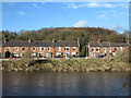
The Geograph project started in 2005 with the aim of publishing, organising and preserving representative images for every square kilometre of Great Britain, Ireland and the Isle of Man.

There are currently over 7.5m images from over14,400 individuals and you can help contribute to the project by visiting https://www.geograph.org.uk
Image Map
Images are licensed for reuse under creativecommons.org/licenses/by-sa/2.0
Notes
- Clicking on the map will re-center to the selected point.
- The higher the marker number, the further away the image location is from the centre of the postcode.
Image Listing (43 Images Found)
Images are licensed for reuse under creativecommons.org/licenses/by-sa/2.0
Image
Details
Distance
1
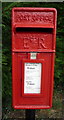
Close up, Elizabeth II postbox, Worm Hill Terrace
Postbox No. NE38 502.
Image: © JThomas
Taken: 18 Aug 2018
0.05 miles
2
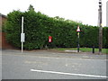
Elizabeth II postbox, Worm Hill Terrace
Postbox No. NE38 502.
Image: © JThomas
Taken: 18 Aug 2018
0.05 miles
3
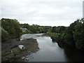
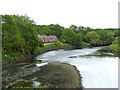
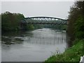
River Wear, Washington
View north east from Penshaw Bridge.
Image: © JThomas
Taken: 18 Aug 2018
0.05 miles
4
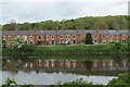
Looking across the River Wear from Mount Pleasant
A long row of terraced houses on South View, as seen from the Weardale Way on the opposite bank.
Image: © Chris Heaton
Taken: 18 May 2023
0.06 miles
5
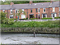
Terraced housing across River Wear
The terrace, possibly known as South View, is on the north side of the River Wear at Fatfield, a district of Washington.
Image: © Trevor Littlewood
Taken: 8 Jan 2014
0.06 miles
6
The River Wear and South View
Looking downstream from Fatfield Bridge. Note the fisherman in the water. See also Image
Image: © Oliver Dixon
Taken: 19 Jun 2015
0.06 miles
7
Worm Hill Terrace, Washington
Looking north west.
Image: © JThomas
Taken: 18 Aug 2018
0.06 miles
8
Worm Hill Terrace Fatfield
Seen from the northern side of Fatfield Bridge Sunderland
Image: © Peter Robinson
Taken: 17 Jan 2010
0.07 miles
9
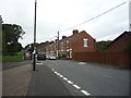
Road Bridge Over the River Wear at Fatfield
A steel girder bridge, opened in 1891. This was a busy main road until 1975 when it was bypassed. Single carriageway with a footpath and managed with traffic lights.
Image: © Brian Abbott
Taken: 14 May 2006
0.07 miles
10
The River Wear and South View
Complete with fisherman in the river. See also Image
Image: © Oliver Dixon
Taken: 19 Jun 2015
0.07 miles