IMAGES TAKEN NEAR TO
Lumley Way, NEWCASTLE UPON TYNE, NE3 5RR
Introduction
This page details the photographs taken nearby to Lumley Way, NE3 5RR by members of the Geograph project.
The Geograph project started in 2005 with the aim of publishing, organising and preserving representative images for every square kilometre of Great Britain, Ireland and the Isle of Man.

There are currently over 7.5m images from over14,400 individuals and you can help contribute to the project by visiting https://www.geograph.org.uk
Image Map
Images are licensed for reuse under creativecommons.org/licenses/by-sa/2.0
Notes
- Clicking on the map will re-center to the selected point.
- The higher the marker number, the further away the image location is from the centre of the postcode.
Image Listing (7 Images Found)
Images are licensed for reuse under creativecommons.org/licenses/by-sa/2.0
Image
Details
Distance
1
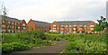
Brunton Park, Newcastle Upon Tyne
Green oasis in the middle of housing.
Image: © wfmillar
Taken: 31 May 2014
0.07 miles
2
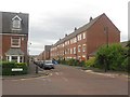
Featherstone Grove, Newcastle Great Park, Newcastle upon Tyne
Terraced town houses on Featherstone Grove in the new Newcastle Great Park suburb.
Image: © Graham Robson
Taken: 10 Jul 2016
0.22 miles
3

Hazlerigg : A1
Heading south on the A1.
Image: © Lewis Clarke
Taken: 25 Sep 2020
0.22 miles
4
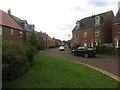
Netherwitton Way, Newcastle Great Park, Newcastle upon Tyne
A residential street in the modern housing development of Melbury Estate which makes up part of the much larger Newcastle Great Park scheme.
Image: © Graham Robson
Taken: 10 Jul 2016
0.22 miles
5
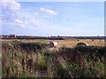
Middle Brunton East Farm
View of land at Middle Brunton East Farm, from Brunton Lane looking south towards Newcastle. The houses at the left hand side are part of the new Great Park development.
Image: © Weston Beggard
Taken: 24 Sep 2005
0.22 miles
6
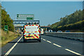
Hazlerigg : A1
Looking north along the A1.
Image: © Lewis Clarke
Taken: 21 Sep 2020
0.23 miles
7
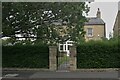
Barmoor Drive, Newcastle Great Park
The former East Brunton Farmhouse after renovation as a dwelling.
Image: © Phil Thirkell
Taken: 13 Sep 2021
0.24 miles