IMAGES TAKEN NEAR TO
Masefield Drive, SOUTH SHIELDS, NE34 9LG
Introduction
This page details the photographs taken nearby to Masefield Drive, NE34 9LG by members of the Geograph project.
The Geograph project started in 2005 with the aim of publishing, organising and preserving representative images for every square kilometre of Great Britain, Ireland and the Isle of Man.

There are currently over 7.5m images from over14,400 individuals and you can help contribute to the project by visiting https://www.geograph.org.uk
Image Map (Loading...)


Getting Data...Please wait
Leaflet Map data © OpenStreetMap
Images are licensed for reuse under creativecommons.org/licenses/by-sa/2.0
Notes
- Clicking on the map will re-center to the selected point.
- The higher the marker number, the further away the image location is from the centre of the postcode.
Image Listing (8 Images Found)
Images are licensed for reuse under creativecommons.org/licenses/by-sa/2.0
Image
Details
Distance
2
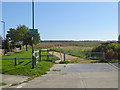
Cycle path in Colliery Wood
Reclaimed from industrial wasteland in Biddick Hall. Note the access control designed to exclude motor bikes. The quality of the path deteriorates greatly before reaching Temple Park.
Image: © Oliver Dixon
Taken: 30 Sep 2015
0.12 miles
3
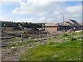
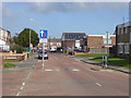
Building site at Colliery Wood, Biddick Hall
Part of the reclaimed industrial wasteland has now been allocated for new housing.
Image: © Oliver Dixon
Taken: 30 Sep 2015
0.12 miles
4
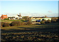
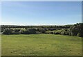
Newton Garths, Biddick Hall
The Garths, now much built on, are on the other side of the River Don, which winds across the centre of the photograph.
Image: © Alan Fearon
Taken: 18 Nov 2005
0.19 miles
5

Path beside playing fields, Chuter Ede School
Looking south.
Image: © JThomas
Taken: 7 Jul 2018
0.20 miles