IMAGES TAKEN NEAR TO
Ebor Street, SOUTH SHIELDS, NE34 9AS
Introduction
This page details the photographs taken nearby to Ebor Street, NE34 9AS by members of the Geograph project.
The Geograph project started in 2005 with the aim of publishing, organising and preserving representative images for every square kilometre of Great Britain, Ireland and the Isle of Man.

There are currently over 7.5m images from over14,400 individuals and you can help contribute to the project by visiting https://www.geograph.org.uk
Image Map
Images are licensed for reuse under creativecommons.org/licenses/by-sa/2.0
Notes
- Clicking on the map will re-center to the selected point.
- The higher the marker number, the further away the image location is from the centre of the postcode.
Image Listing (10 Images Found)
Images are licensed for reuse under creativecommons.org/licenses/by-sa/2.0
Image
Details
Distance

4
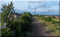
Railway line in West Harton, South Tyneside
Image: © Mat Fascione
Taken: 27 Aug 2017
0.17 miles
5
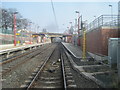
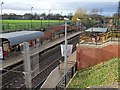
Simonside Metro station, Tyne & Wear
Opened in 2008 by the Tyne & Wear Metro on the line from Pelaw to South Shields.
View east towards Tyne Dock and South Shields.
Image: © Nigel Thompson
Taken: 24 Mar 2012
0.23 miles
7
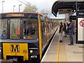
Train at Simonside Metro Station (Platform 1)
Image: © Andrew Curtis
Taken: 27 Nov 2015
0.23 miles
8
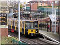
Train at Simonside Metro Station (Platform 2)
Image: © Andrew Curtis
Taken: 27 Nov 2015
0.23 miles
9

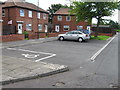
Wenlock Road in Simonside, South Tyneside
Image: © Mat Fascione
Taken: 27 Aug 2017
0.24 miles
10

Railwayline, South Shields
See earlier photo I took
Image: © Alex McGregor
Taken: 7 Jun 2012
0.25 miles