IMAGES TAKEN NEAR TO
Cloister Avenue, SOUTH SHIELDS, NE34 9AQ
Introduction
This page details the photographs taken nearby to Cloister Avenue, NE34 9AQ by members of the Geograph project.
The Geograph project started in 2005 with the aim of publishing, organising and preserving representative images for every square kilometre of Great Britain, Ireland and the Isle of Man.

There are currently over 7.5m images from over14,400 individuals and you can help contribute to the project by visiting https://www.geograph.org.uk
Image Map (Loading...)


Getting Data...Please wait
Leaflet Map data © OpenStreetMap
Images are licensed for reuse under creativecommons.org/licenses/by-sa/2.0
Notes
- Clicking on the map will re-center to the selected point.
- The higher the marker number, the further away the image location is from the centre of the postcode.
Image Listing (17 Images Found)
Images are licensed for reuse under creativecommons.org/licenses/by-sa/2.0
Image
Details
Distance
1

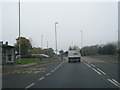
Wenlock Road in Simonside, South Tyneside
Image: © Mat Fascione
Taken: 27 Aug 2017
0.10 miles
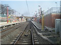
3

Train at Simonside Metro Station (Platform 1)
Image: © Andrew Curtis
Taken: 27 Nov 2015
0.11 miles
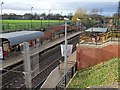
4
Simonside Metro station, Tyne & Wear
Opened in 2008 by the Tyne & Wear Metro on the line from Pelaw to South Shields.
View east towards Tyne Dock and South Shields.
Image: © Nigel Thompson
Taken: 24 Mar 2012
0.11 miles
5
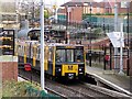
Train at Simonside Metro Station (Platform 2)
Image: © Andrew Curtis
Taken: 27 Nov 2015
0.12 miles
6
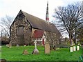
Church of St Simon, Simonside
The Grade II Listed church has a variety of unusual features. It is a simple rectangular building in late gothic style without aisles or separate chancel. The vestry is on the north side and a nice gabled porch on the south with decorated bargeboards and other detail. An elegant octagonal fleche marks the position of the chancel. The side windows are all square headed, the west window has a segmental hood and the east window a pointed one.
http://www.southtyneside.gov.uk/applications/2/listedbuildings/buildingdetail.aspx?id=1625001402000&street=wenlock%20road&area=south%20shields&building=CHURCH%20OF%20ST%20SIMON
The graveyard contains eight Commonwealth War Graves - three can be seen on the right.
Image: © Andrew Curtis
Taken: 27 Nov 2015
0.12 miles
7
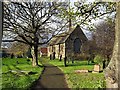
Church of St Simon, Simonside
See description here Image
Image: © Andrew Curtis
Taken: 27 Nov 2015
0.12 miles

9
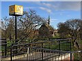
Church of St Simon near Simonside Metro Station
The church is shown here Image
Image: © Andrew Curtis
Taken: 27 Nov 2015
0.13 miles