IMAGES TAKEN NEAR TO
Fennel Grove, SOUTH SHIELDS, NE34 8TN
Introduction
This page details the photographs taken nearby to Fennel Grove, NE34 8TN by members of the Geograph project.
The Geograph project started in 2005 with the aim of publishing, organising and preserving representative images for every square kilometre of Great Britain, Ireland and the Isle of Man.

There are currently over 7.5m images from over14,400 individuals and you can help contribute to the project by visiting https://www.geograph.org.uk
Image Map
Images are licensed for reuse under creativecommons.org/licenses/by-sa/2.0
Notes
- Clicking on the map will re-center to the selected point.
- The higher the marker number, the further away the image location is from the centre of the postcode.
Image Listing (4 Images Found)
Images are licensed for reuse under creativecommons.org/licenses/by-sa/2.0
Image
Details
Distance
1
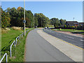
Nevinson Avenue, Whiteleas
Broad thoroughfare, with segregated cycle track alongside.
Image: © Oliver Dixon
Taken: 30 Sep 2015
0.15 miles
2
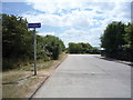
Holder House Way
Looking south.
Continues as a cycle route towards Tileshead Nature Reserve.
Image: © JThomas
Taken: 7 Jul 2018
0.20 miles
4
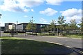
South Shields School
A large and modern school building off Nevinson Avenue in South Shields. The school provides education to children between the ages of 11 and 16.
Image: © Graham Robson
Taken: 23 Sep 2018
0.24 miles