IMAGES TAKEN NEAR TO
The Lonnen, SOUTH SHIELDS, NE34 8EA
Introduction
This page details the photographs taken nearby to The Lonnen, NE34 8EA by members of the Geograph project.
The Geograph project started in 2005 with the aim of publishing, organising and preserving representative images for every square kilometre of Great Britain, Ireland and the Isle of Man.

There are currently over 7.5m images from over14,400 individuals and you can help contribute to the project by visiting https://www.geograph.org.uk
Image Map (Loading...)


Getting Data...Please wait
Leaflet Map data © OpenStreetMap
Images are licensed for reuse under creativecommons.org/licenses/by-sa/2.0
Notes
- Clicking on the map will re-center to the selected point.
- The higher the marker number, the further away the image location is from the centre of the postcode.
Image Listing (13 Images Found)
Images are licensed for reuse under creativecommons.org/licenses/by-sa/2.0
Image
Details
Distance
1
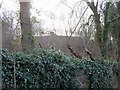
Covered reservoir, Cleadon Pumping Station
"The covered reservoir is the most unusual of all the structures in this zone, significant in size and historical development. Its circular shape with a smooth light grey 50m diameter concrete dome makes it difficult to appreciate in its entirety, and it is generally only glimpsed over walls, through trees
and behind buildings from both within and outside the site. From the top of the chimney, however, its vast proportions are quite dramatic. It is currently fenced off and inaccessible."
"This is an unusual large circular domed structure with no aboveground sidewalls. Historic photographs show it is about 6m deep, sunken into the ground and lined with irregular coursed stone, originally with a stone set floor and ornate railings around its rim. This is all now concealed by the stark light grey concrete dome, added in 1954."
"... water which was piped away under ground to the large circular reservoir, which held 2 million gallons of water. This reservoir was covered in 1954 by what was reputed to then be the largest unsupported concrete dome in Europe."
Cleadon Hills Conservation Area Character Appraisal (2007).
Image: © Andrew Curtis
Taken: 30 Jan 2020
0.13 miles
2
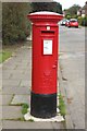
Postbox, Cleadon Hill Road, Cleadon Park
A pillar box on the side of Cleadon Hill Road in the Cleadon Park area of housing.
Image: © Graham Robson
Taken: 23 Sep 2018
0.13 miles
3
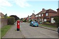
Cleadon Hill Road, Cleadon Park
Looking along a quiet residential street in Cleadon Park. The postbox on the pavement ahead can be seen in more detail in Image
Image: © Graham Robson
Taken: 23 Sep 2018
0.13 miles
4
Water pumping station, Cleadon
The chimney of this Neo-italianate building is visible in this shot. Built in 1863, by Thomas Hawksley.
Image: © Roger Cornfoot
Taken: 16 Apr 2007
0.14 miles
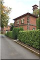
5
Cleadon Pumping station - engine house
A former Sunderland & South Shields Water Company engine house that was designed by Thomas Hawksley and commenced work in 1862. The boiler house is behind and the ornate square chimney stands alone.
Image: © Chris Allen
Taken: 12 Sep 2024
0.15 miles
6
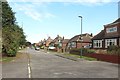
Cleadon Hill Road, Cleadon Park
A residential street with a mixture of house types though all look to be of a similar age and style.
Image: © Graham Robson
Taken: 23 Sep 2018
0.17 miles
7
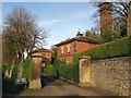
Entrance to Cleadon Water Pumping Station
"The squared stone entrance gateway pillars and high gates have a telecom system, but the attractive wooded site and fine buildings are visible beyond."
Cleadon Hills Conservation Area Character Appraisal (2007).
Image: © Andrew Curtis
Taken: 30 Jan 2020
0.17 miles
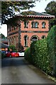
8
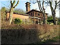
Buildings at the former Cleadon Pumping Station
The ornately designed buildings of the former Cleadon Pumping Station have been retained and appear to have been converted into houses. The buildings and the chimney are grade II listed: https://historicengland.org.uk/listing/the-list/list-entry/1232322 and https://historicengland.org.uk/listing/the-list/list-entry/1416041
Image: © Graham Robson
Taken: 23 Sep 2018
0.17 miles
9
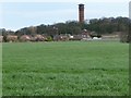
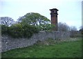
Water pumping station chimney, Cleadon Hill
Built for a steam engine in 1863. See Image for a closer view.
Image: © Christine Johnstone
Taken: 25 Feb 2017
0.18 miles
10
Cleadon Pumping Station
The pumping station was originally operated by steam from coal fired Cornish boilers, using about 470 lbs of coal per hour, powering two Cornish Beam engines which in turn drove combined ram and bucket pumps down into the 269.88 feet deep (12 ft diameter) well below the Engine House. The resultant vacuum produced in the shaft by the ‘ram and bucket’ moving up and down, drew up the water which was piped away under ground to the large circular reservoir, which held 2 million gallons of water. This reservoir was covered in 1954 by what was reputed to then be the largest unsupported concrete dome in Europe. About 1.5 million gallons of water was extracted each 12 hour day. The tall (100 feet) Italianate listed tower on the higher land above was actually a ‘chimney’ that provided a draught for the boilers as well as dispersing waste gases from the squat Boiler House which is attached to the taller Engine House in the centre of the site. The ‘artificial’ cooling pond to the south of the site, fed by water from the well but now a shallow grass depression, was needed because the site did not have a natural surface stream, a characteristic typical of limestone areas. Water from the cooling pond was recycled after use via underground pipes back into the cooling pond.
Cleadon Hills Conservation Area Character Appraisal (2007).
Image: © Andrew Curtis
Taken: 30 Jan 2020
0.18 miles