IMAGES TAKEN NEAR TO
Sunniside Drive, SOUTH SHIELDS, NE34 8DT
Introduction
This page details the photographs taken nearby to Sunniside Drive, NE34 8DT by members of the Geograph project.
The Geograph project started in 2005 with the aim of publishing, organising and preserving representative images for every square kilometre of Great Britain, Ireland and the Isle of Man.

There are currently over 7.5m images from over14,400 individuals and you can help contribute to the project by visiting https://www.geograph.org.uk
Image Map (Loading...)


Getting Data...Please wait
Leaflet Map data © OpenStreetMap
Images are licensed for reuse under creativecommons.org/licenses/by-sa/2.0
Notes
- Clicking on the map will re-center to the selected point.
- The higher the marker number, the further away the image location is from the centre of the postcode.
Image Listing (22 Images Found)
Images are licensed for reuse under creativecommons.org/licenses/by-sa/2.0
Image
Details
Distance
1
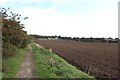
Bridleway alongside the edge of Cleadon Park
A bridleway following the boundary between the Cleadon Park area of housing and arable land. The fields have recently been cultivated following the harvest of a previous crop.
Image: © Graham Robson
Taken: 23 Sep 2018
0.12 miles
2
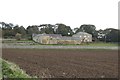
Looking across farmland to Sunniside Farm
Sunniside Farm (no longer a working farm) is seen across an area of cultivated arable land beside the Cleadon Park area of South Shields.
Image: © Graham Robson
Taken: 23 Sep 2018
0.13 miles
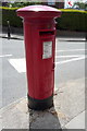
3
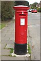
Postbox, Cleadon Hill Road, Cleadon Park
A pillar box on the side of Cleadon Hill Road in the Cleadon Park area of housing.
Image: © Graham Robson
Taken: 23 Sep 2018
0.14 miles
4
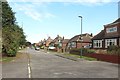
Cleadon Hill Road, Cleadon Park
A residential street with a mixture of house types though all look to be of a similar age and style.
Image: © Graham Robson
Taken: 23 Sep 2018
0.14 miles
5
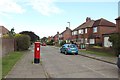
Cleadon Hill Road, Cleadon Park
Looking along a quiet residential street in Cleadon Park. The postbox on the pavement ahead can be seen in more detail in Image
Image: © Graham Robson
Taken: 23 Sep 2018
0.15 miles
6
George V postbox on Sunderland Road
Postbox No. NE34 62.
See Image] for context.
Image: © JThomas
Taken: 7 Jul 2018
0.19 miles
7
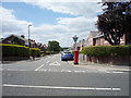
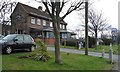
The Ridgeway, Cleadon Park
Showing position of George V postbox on Sunderland Road.
Postbox No. NE34 62.
See Image] for postbox.
Image: © JThomas
Taken: 7 Jul 2018
0.19 miles
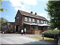
9
The New Ship, Sunderland Road, South Shields
A pub with a carvery and restaurant.
Image: © Christine Johnstone
Taken: 25 Feb 2017
0.19 miles
10
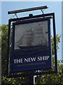
Sign for The New Ship Inn, Cleadon, South Shields
Image: © JThomas
Taken: 7 Jul 2018
0.19 miles