IMAGES TAKEN NEAR TO
Browntop Place, SOUTH SHIELDS, NE34 0XJ
Introduction
This page details the photographs taken nearby to Browntop Place, NE34 0XJ by members of the Geograph project.
The Geograph project started in 2005 with the aim of publishing, organising and preserving representative images for every square kilometre of Great Britain, Ireland and the Isle of Man.

There are currently over 7.5m images from over14,400 individuals and you can help contribute to the project by visiting https://www.geograph.org.uk
Image Map (Loading...)


Getting Data...Please wait
Leaflet Map data © OpenStreetMap
Images are licensed for reuse under creativecommons.org/licenses/by-sa/2.0
Notes
- Clicking on the map will re-center to the selected point.
- The higher the marker number, the further away the image location is from the centre of the postcode.
Image Listing (10 Images Found)
Images are licensed for reuse under creativecommons.org/licenses/by-sa/2.0
Image
Details
Distance
1
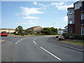
Bend on Low Lane, South Shields
Looking east.
Image: © JThomas
Taken: 7 Jul 2018
0.17 miles

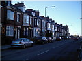
3

The Winskells, South Shields
Former public house on Boldon Lane.
Image: © JThomas
Taken: 7 Jul 2018
0.20 miles
4
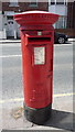
Elizabeth II postbox on Boldon Lane
Postbox No. NE34 47.
See Image] for context
Image: © JThomas
Taken: 7 Jul 2018
0.23 miles
5

Shops on Boldon Lane, South Shields
Showing position of Postbox No. NE34 47.
See Image] for postbox.
Image: © JThomas
Taken: 7 Jul 2018
0.23 miles
6
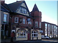
Stanhope Public House
On Stanhope Road, West Park stands this mock-tudor, victorian effort.
Image: © MSX
Taken: 12 Nov 2005
0.24 miles
8
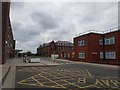
Ambulance bays
Looking along the front of South Tyneside District Hospital.
Image: © DS Pugh
Taken: 28 Apr 2020
0.24 miles
9
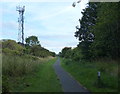
Cycleway and footpath at West Harton, South Tyneside
Image: © Mat Fascione
Taken: 27 Aug 2017
0.24 miles
10
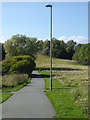
Path in Temple Memorial Park
In 1961 the Ecclesiastical Commissioners gifted the Park to the people of South Shields, in recognition of the part they played in winning the 1939 - 1945 war at sea. The Park is named in memory of a former Archbishop of Canterbury, Archbishop Temple (1881 - 1944).
A program of path building and improvement was initiated in 2011. This path is signed "John Reid Way". Is this the same John Reid who was a prominent member of the last Labour government?
Image: © Oliver Dixon
Taken: 30 Sep 2015
0.25 miles