IMAGES TAKEN NEAR TO
Studdon Walk, NEWCASTLE UPON TYNE, NE3 3YQ
Introduction
This page details the photographs taken nearby to Studdon Walk, NE3 3YQ by members of the Geograph project.
The Geograph project started in 2005 with the aim of publishing, organising and preserving representative images for every square kilometre of Great Britain, Ireland and the Isle of Man.

There are currently over 7.5m images from over14,400 individuals and you can help contribute to the project by visiting https://www.geograph.org.uk
Image Map
Images are licensed for reuse under creativecommons.org/licenses/by-sa/2.0
Notes
- Clicking on the map will re-center to the selected point.
- The higher the marker number, the further away the image location is from the centre of the postcode.
Image Listing (6 Images Found)
Images are licensed for reuse under creativecommons.org/licenses/by-sa/2.0
Image
Details
Distance
1
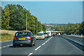
Woolsington : A1
Looking north along the A1.
Image: © Lewis Clarke
Taken: 21 Sep 2020
0.14 miles
2
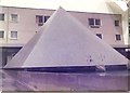
Kenton Bar Pyramid
This was one of the iconic landmarks on Kenton Bar Estate. Now it has been demolished..... very few pictures of it exist although a lot of memories.............remain. More images can be found at http://kentonbar.blogspot.com
Image: © El Patron
Taken: 1 Jan 1977
0.16 miles
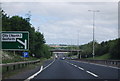
5
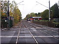
Kingston Park Metro Station
View shows the level crossing at Kingston Park Metro station
Image: © Weston Beggard
Taken: 23 Oct 2005
0.24 miles
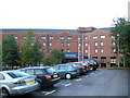
6
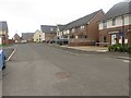
New houses, Fawdon, Newcastle upon Tyne
A new housing development at the north west corner of Fawdon.
Image: © Graham Robson
Taken: 10 Jul 2016
0.25 miles