IMAGES TAKEN NEAR TO
Ambridge Way, NEWCASTLE UPON TYNE, NE3 3SS
Introduction
This page details the photographs taken nearby to Ambridge Way, NE3 3SS by members of the Geograph project.
The Geograph project started in 2005 with the aim of publishing, organising and preserving representative images for every square kilometre of Great Britain, Ireland and the Isle of Man.

There are currently over 7.5m images from over14,400 individuals and you can help contribute to the project by visiting https://www.geograph.org.uk
Image Map
Images are licensed for reuse under creativecommons.org/licenses/by-sa/2.0
Notes
- Clicking on the map will re-center to the selected point.
- The higher the marker number, the further away the image location is from the centre of the postcode.
Image Listing (7 Images Found)
Images are licensed for reuse under creativecommons.org/licenses/by-sa/2.0
Image
Details
Distance
1
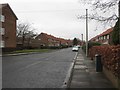
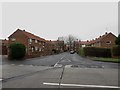
Edgefield Avenue, Kenton
A residential street in the Kenton area of Newcastle.
Image: © Graham Robson
Taken: 10 Feb 2018
0.17 miles
2
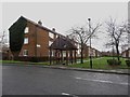
Mostyn Green flats, Kenton
A long block of flats off Kenton Road. The block is mirrored on the other side of a central green space.
Image: © Graham Robson
Taken: 10 Feb 2018
0.17 miles
5
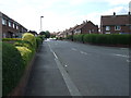
Crantock Road, Kenton
A short residential street with terraced houses on either side in Kenton.
Image: © Graham Robson
Taken: 10 Feb 2018
0.22 miles
6
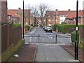
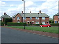
Walkway in Kenton
Walkway forming a link between Purley Gardens and Kirkwood Drive. Crantock Road straight ahead. Further away is another walkway through to Fulbrook Road.
Image: © Oliver Dixon
Taken: 1 Feb 2013
0.23 miles
7
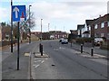
Traffic calming on Hillview Avenue, Fawdon
Image: © Oliver Dixon
Taken: 1 Feb 2013
0.23 miles