IMAGES TAKEN NEAR TO
Westoe Road, SOUTH SHIELDS, NE33 9SR
Introduction
This page details the photographs taken nearby to Westoe Road, NE33 9SR by members of the Geograph project.
The Geograph project started in 2005 with the aim of publishing, organising and preserving representative images for every square kilometre of Great Britain, Ireland and the Isle of Man.

There are currently over 7.5m images from over14,400 individuals and you can help contribute to the project by visiting https://www.geograph.org.uk
Image Map
Images are licensed for reuse under creativecommons.org/licenses/by-sa/2.0
Notes
- Clicking on the map will re-center to the selected point.
- The higher the marker number, the further away the image location is from the centre of the postcode.
Image Listing (15 Images Found)
Images are licensed for reuse under creativecommons.org/licenses/by-sa/2.0
Image
Details
Distance
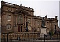
1
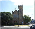
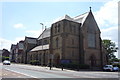
St John's Presbyterian Church, South Shields
Image: © JThomas
Taken: 7 Jul 2018
0.04 miles
2
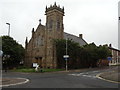
St John's Presbyterian Church, Beach Road, South Shields
Image: © Bill Henderson
Taken: 11 Jun 2012
0.04 miles
3
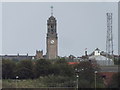
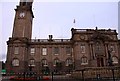
Town Hall, South Shields
Landmark Edwardian (1910) building, seen here from the North Shields car ferry terminal.
Image: © Colin Smith
Taken: 9 Sep 2012
0.05 miles
6
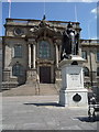
Queen Victoria statue outside the town hall, South Shields
Image: © JThomas
Taken: 7 Jul 2018
0.08 miles
7
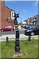
Millennium Milepost, South Shields
On route 1 of the National Cycle Network
Image: © Richard Webb
Taken: 18 Jun 2013
0.09 miles
8

Shared use path, South Shields
A former railway in what is now a linear park.
Image: © Richard Webb
Taken: 18 Jun 2013
0.10 miles
10
St Bede Roman Catholic Church, South Shields
Image: © JThomas
Taken: 7 Jul 2018
0.13 miles