IMAGES TAKEN NEAR TO
Western Approach, SOUTH SHIELDS, NE33 5NN
Introduction
This page details the photographs taken nearby to Western Approach, NE33 5NN by members of the Geograph project.
The Geograph project started in 2005 with the aim of publishing, organising and preserving representative images for every square kilometre of Great Britain, Ireland and the Isle of Man.

There are currently over 7.5m images from over14,400 individuals and you can help contribute to the project by visiting https://www.geograph.org.uk
Image Map (Loading...)


Getting Data...Please wait
Leaflet Map data © OpenStreetMap
Images are licensed for reuse under creativecommons.org/licenses/by-sa/2.0
Notes
- Clicking on the map will re-center to the selected point.
- The higher the marker number, the further away the image location is from the centre of the postcode.
Image Listing (23 Images Found)
Images are licensed for reuse under creativecommons.org/licenses/by-sa/2.0
Image
Details
Distance
1

Traffic trying to get into South Shields for the Great North Run
South Shields town centre is ahead, with the tower of the municipal buildings showing.
Image: © Bill Boaden
Taken: 18 Sep 2011
0.07 miles
2
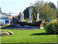
Roundabout artwork, South Shields
This large model of a three-masted ship is located on the roundabout where Station Road, Crossgate and Western Approach converge. Probably installed recently, as it is not mentioned on official lists of the various artworks and sculptures in South Shields.
Image: © Oliver Dixon
Taken: 30 Sep 2015
0.12 miles
3
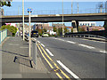
Crossgate, South Shields
Broad street leading towards South Shields Town Hall which can be seen to the left. The Tyne and Wear Metro passes overhead. In the foreground, National Cycle Network route 14 turns off along an alleyway.
Image: © Oliver Dixon
Taken: 30 Sep 2015
0.13 miles
4
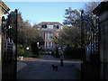
Ingham Infirmary
Opened in 1874 by public subscription. No longer a hospital, it closed sometime in the 1990's. See http://southshieldsdailyphoto.wordpress.com/2007/01/page/2/
Image: © MSX
Taken: 12 Nov 2005
0.13 miles
5
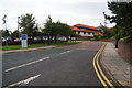
Area Command for Northumbria Police
This covers the South Tyneside area.
Image: © Bill Boaden
Taken: 18 Sep 2011
0.14 miles
7
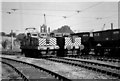
Electric Locomotives at St Hilda Sidings
Till 1989 spoil from Westoe Colliery was taken by rail to staithes on the river Tyne. This was part of much wider electric rail system that once existed but which by the late 1980s only covered the final section via a very low tunnel that linked St Hilda siding with Harton Low staithes on the river and which diesel locomotives could not use. In 1989 the entire operation was converted to a conveyor belt and this photo was taken on the final day of rail operation when No12 and No13 were at St Hilda's although only No 13 was in use.
Image: © Ian Robinson
Taken: 19 Jul 1989
0.19 miles
8
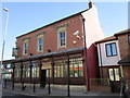
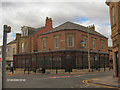
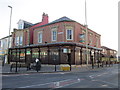
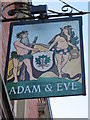
The Adam and Eve, South Shields
The only Sam Smith's public house in South Shields.
Image: © Ian S
Taken: 5 Apr 2012
0.20 miles
9
The Adam and Eve, South Shields
The only Sam Smith's public house in South Shields.
Image: © Ian S
Taken: 5 Apr 2012
0.20 miles
10
The Adam and Eve, South Shields
The only Sam Smith's public house in South Shields.
Image: © Ian S
Taken: 5 Apr 2012
0.20 miles