IMAGES TAKEN NEAR TO
Dean Road, SOUTH SHIELDS, NE33 5LG
Introduction
This page details the photographs taken nearby to Dean Road, NE33 5LG by members of the Geograph project.
The Geograph project started in 2005 with the aim of publishing, organising and preserving representative images for every square kilometre of Great Britain, Ireland and the Isle of Man.

There are currently over 7.5m images from over14,400 individuals and you can help contribute to the project by visiting https://www.geograph.org.uk
Image Map (Loading...)


Getting Data...Please wait
Leaflet Map data © OpenStreetMap
Images are licensed for reuse under creativecommons.org/licenses/by-sa/2.0
Notes
- Clicking on the map will re-center to the selected point.
- The higher the marker number, the further away the image location is from the centre of the postcode.
Image Listing (3 Images Found)
Images are licensed for reuse under creativecommons.org/licenses/by-sa/2.0
Image
Details
Distance
1
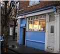
Fat Bobs
Fat Bobs fish and chip shop.
Image: © Colin Kinnear
Taken: 11 Dec 2008
0.19 miles
2
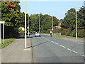
Elsdon Road, South Shields
Relatively quiet and wide, Elsdon Road is followed by National Cycle Network route 14.
Image: © Oliver Dixon
Taken: 30 Sep 2015
0.22 miles
3
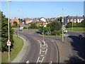
Roundabout on the A194
The A194 (Jarrow Road in the foreground) bears left at the roundabout for South Shields. The road entering the roundabout from the right is West Way; ahead is Dean Street.
Image: © Oliver Dixon
Taken: 30 Sep 2015
0.22 miles