IMAGES TAKEN NEAR TO
Stanhope Road, SOUTH SHIELDS, NE33 4RT
Introduction
This page details the photographs taken nearby to Stanhope Road, NE33 4RT by members of the Geograph project.
The Geograph project started in 2005 with the aim of publishing, organising and preserving representative images for every square kilometre of Great Britain, Ireland and the Isle of Man.

There are currently over 7.5m images from over14,400 individuals and you can help contribute to the project by visiting https://www.geograph.org.uk
Image Map
Images are licensed for reuse under creativecommons.org/licenses/by-sa/2.0
Notes
- Clicking on the map will re-center to the selected point.
- The higher the marker number, the further away the image location is from the centre of the postcode.
Image Listing (7 Images Found)
Images are licensed for reuse under creativecommons.org/licenses/by-sa/2.0
Image
Details
Distance
1
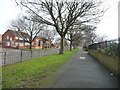
Cycleway on Temple Park Road pavement
Immediately east of Stanhope Road, opposite Birchington Road.
Image: © Christine Johnstone
Taken: 25 Feb 2017
0.06 miles
2
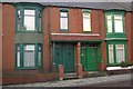
Green Doors
Green doors and windows, Birchington Avenue, South Shields.
Image: © Colin Kinnear
Taken: 12 Dec 2008
0.15 miles
3
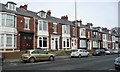
Maisonettes on Stanhope Road
The pairs of front doors reveal that these 'terraced houses' are in fact first floor and ground floor flats.
Image: © Christine Johnstone
Taken: 25 Feb 2017
0.17 miles

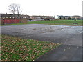
6
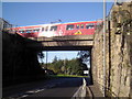
West Park Metro Bridge
This bridge straddles the West Way and is not far from Tyne Dock Station.
Image: © MSX
Taken: 12 Nov 2005
0.25 miles
7
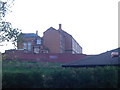
Stanhope County School
Eerie looking Victorian school imposing atop a hill.
Image: © MSX
Taken: 12 Nov 2005
0.25 miles