IMAGES TAKEN NEAR TO
Derwentwater Terrace, SOUTH SHIELDS, NE33 4JL
Introduction
This page details the photographs taken nearby to Derwentwater Terrace, NE33 4JL by members of the Geograph project.
The Geograph project started in 2005 with the aim of publishing, organising and preserving representative images for every square kilometre of Great Britain, Ireland and the Isle of Man.

There are currently over 7.5m images from over14,400 individuals and you can help contribute to the project by visiting https://www.geograph.org.uk
Image Map (Loading...)


Getting Data...Please wait
Leaflet Map data © OpenStreetMap
Images are licensed for reuse under creativecommons.org/licenses/by-sa/2.0
Notes
- Clicking on the map will re-center to the selected point.
- The higher the marker number, the further away the image location is from the centre of the postcode.
Image Listing (15 Images Found)
Images are licensed for reuse under creativecommons.org/licenses/by-sa/2.0
Image
Details
Distance
2
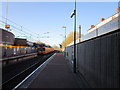
Chichester Metro station, Tyne & Wear
Opened in 1984 by the Tyne & Wear Metro on the line from Pelaw to South Shields.
View north towards South Shields.
Image: © Nigel Thompson
Taken: 24 Mar 2012
0.03 miles
3

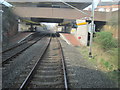
Chichester Metro station
Chy-Chester please!
Image: © Chris Morgan
Taken: 9 Jun 2018
0.03 miles
4
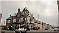
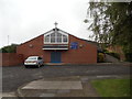
The Cyprus Hotel
A Cameron's traditional pub dating to 1901
Image: © Chris Morgan
Taken: 9 Jun 2018
0.08 miles
7
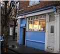
Fat Bobs
Fat Bobs fish and chip shop.
Image: © Colin Kinnear
Taken: 11 Dec 2008
0.20 miles
8
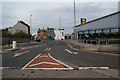
Laygate, High Shields
The Lidl on the right is a fairly recent development.
Image: © Bill Boaden
Taken: 18 Sep 2011
0.24 miles
10
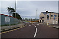
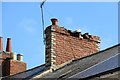
Reed Street
A lot of former buildings on this road were fairly recently demolished prior to redevelopment.
Image: © Bill Boaden
Taken: 18 Sep 2011
0.24 miles