IMAGES TAKEN NEAR TO
Darras Court, SOUTH SHIELDS, NE33 4HT
Introduction
This page details the photographs taken nearby to Darras Court, NE33 4HT by members of the Geograph project.
The Geograph project started in 2005 with the aim of publishing, organising and preserving representative images for every square kilometre of Great Britain, Ireland and the Isle of Man.

There are currently over 7.5m images from over14,400 individuals and you can help contribute to the project by visiting https://www.geograph.org.uk
Image Map
Images are licensed for reuse under creativecommons.org/licenses/by-sa/2.0
Notes
- Clicking on the map will re-center to the selected point.
- The higher the marker number, the further away the image location is from the centre of the postcode.
Image Listing (12 Images Found)
Images are licensed for reuse under creativecommons.org/licenses/by-sa/2.0
Image
Details
Distance
1
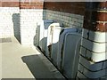
Westoe Netty
These were the toilets that used to be on the corner of Imeary Street and Chichester Road in the 1970s; they were nick-named Westoe Netty. I took this photo at Beamish where they had rebuilt the toilets for show but now they have demolished them. I can still remember using them after coming from Derby Street baths when I was about 14.
Image: © Terry
Taken: 10 Jul 2009
0.09 miles
2
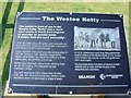
Westoe Netty Plaque
This is the Plaque that was outside the toilets at Beamish giving the history of the Westoe Netty.
Image: © Terry
Taken: 10 Jul 2009
0.09 miles
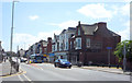
4
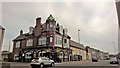
The Cyprus Hotel
A Cameron's traditional pub dating to 1901
Image: © Chris Morgan
Taken: 9 Jun 2018
0.16 miles
5
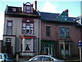
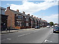
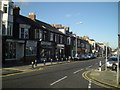
Terraced Housing, Westoe Road
Wonky old Tyneside Terracing.
Image: © MSX
Taken: 12 Nov 2005
0.18 miles
6
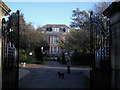
Ingham Infirmary
Opened in 1874 by public subscription. No longer a hospital, it closed sometime in the 1990's. See http://southshieldsdailyphoto.wordpress.com/2007/01/page/2/
Image: © MSX
Taken: 12 Nov 2005
0.19 miles
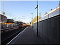
7
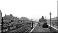
Westoe Lane station, South Shields & Whitburn Colliery Railway, 1953
The view is westward, towards Tyne Dock and Whitburn Junction. In the opposite direction ran the S.S. & W.C. Railway to Whitburn Colliery, which closed five months later on 23/11/53 along with this station, also the line from Westoe Colliery which lasted until 1993. Ahead the lines were goods only, but electrified, conveying the mineral traffic to Tyne Dock staithes or onto the ex-NER lines. (See also Image]).
Image: © Ben Brooksbank
Taken: 28 Jun 1953
0.20 miles