IMAGES TAKEN NEAR TO
Wawn Street, SOUTH SHIELDS, NE33 4EB
Introduction
This page details the photographs taken nearby to Wawn Street, NE33 4EB by members of the Geograph project.
The Geograph project started in 2005 with the aim of publishing, organising and preserving representative images for every square kilometre of Great Britain, Ireland and the Isle of Man.

There are currently over 7.5m images from over14,400 individuals and you can help contribute to the project by visiting https://www.geograph.org.uk
Image Map
Images are licensed for reuse under creativecommons.org/licenses/by-sa/2.0
Notes
- Clicking on the map will re-center to the selected point.
- The higher the marker number, the further away the image location is from the centre of the postcode.
Image Listing (12 Images Found)
Images are licensed for reuse under creativecommons.org/licenses/by-sa/2.0
Image
Details
Distance
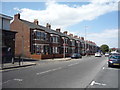
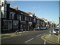
2
Terraced Housing, Westoe Road
Wonky old Tyneside Terracing.
Image: © MSX
Taken: 12 Nov 2005
0.12 miles

4

The Westoe public house
Horsley Hill Road, South Shields.
Image: © JThomas
Taken: 7 Jul 2018
0.15 miles
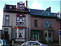
5
The Cyprus Hotel
A Cameron's traditional pub dating to 1901
Image: © Chris Morgan
Taken: 9 Jun 2018
0.19 miles
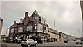
6

The County public house, South Shields
On Sunderland Road.
Image: © JThomas
Taken: 7 Jul 2018
0.21 miles
9

Chichester Metro station
Chy-Chester please!
Image: © Chris Morgan
Taken: 9 Jun 2018
0.23 miles
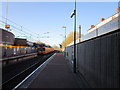
10
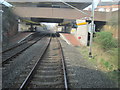
Chichester Metro station, Tyne & Wear
Opened in 1984 by the Tyne & Wear Metro on the line from Pelaw to South Shields.
View north towards South Shields.
Image: © Nigel Thompson
Taken: 24 Mar 2012
0.24 miles