IMAGES TAKEN NEAR TO
Muirfield, SOUTH SHIELDS, NE33 3JE
Introduction
This page details the photographs taken nearby to Muirfield, NE33 3JE by members of the Geograph project.
The Geograph project started in 2005 with the aim of publishing, organising and preserving representative images for every square kilometre of Great Britain, Ireland and the Isle of Man.

There are currently over 7.5m images from over14,400 individuals and you can help contribute to the project by visiting https://www.geograph.org.uk
Image Map
Images are licensed for reuse under creativecommons.org/licenses/by-sa/2.0
Notes
- Clicking on the map will re-center to the selected point.
- The higher the marker number, the further away the image location is from the centre of the postcode.
Image Listing (8 Images Found)
Images are licensed for reuse under creativecommons.org/licenses/by-sa/2.0
Image
Details
Distance
2
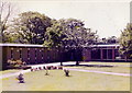
Dr. Winterbottom Hall, South Shields
This is the inner garden area of Doctor Winterbottom Hall, one of the halls of residence at South Shields Marine and Technical College, seen from my bedroom window in the summer of 1979. The reception area was on the left, a refectory on the right.
Image: © Stephen Williams
Taken: Unknown
0.10 miles
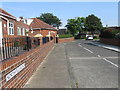
3
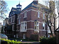
Splendid Property
One of many ridiculously large and expensive-looking houses in Westoe Village.
Image: © MSX
Taken: 12 Nov 2005
0.14 miles
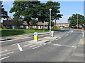
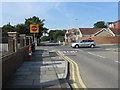
4
Bent's Park Road Roundabout
Quaint maritime motif.
Image: © MSX
Taken: 12 Nov 2005
0.14 miles
7
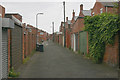
Back lane, South Shields
This is the back lane between Coleridge Avenue (left) and Roseberry Avenue (right).
Image: © David Kemp
Taken: 20 Jul 2013
0.24 miles
8
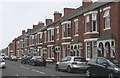
Coleridge Avenue, South Shields
Taken from the corner of Readhead Avenue.
Image: © David Kemp
Taken: 20 Jul 2013
0.24 miles