IMAGES TAKEN NEAR TO
Fowler Street, SOUTH SHIELDS, NE33 1NU
Introduction
This page details the photographs taken nearby to Fowler Street, NE33 1NU by members of the Geograph project.
The Geograph project started in 2005 with the aim of publishing, organising and preserving representative images for every square kilometre of Great Britain, Ireland and the Isle of Man.

There are currently over 7.5m images from over14,400 individuals and you can help contribute to the project by visiting https://www.geograph.org.uk
Image Map
Images are licensed for reuse under creativecommons.org/licenses/by-sa/2.0
Notes
- Clicking on the map will re-center to the selected point.
- The higher the marker number, the further away the image location is from the centre of the postcode.
Image Listing (73 Images Found)
Images are licensed for reuse under creativecommons.org/licenses/by-sa/2.0
Image
Details
Distance
1
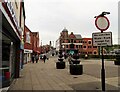
Looking along Fowler Street in South Shields
Town centre view from the junction with Ocean Road. The clock tower in the distance is on the Town Hall, opened in 1910.
Image: © Robert Graham
Taken: 9 May 2022
0.03 miles
3
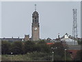
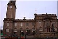
Town Hall, South Shields
Landmark Edwardian (1910) building, seen here from the North Shields car ferry terminal.
Image: © Colin Smith
Taken: 9 Sep 2012
0.10 miles
5
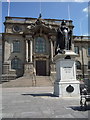
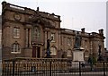
Queen Victoria statue outside the town hall, South Shields
Image: © JThomas
Taken: 7 Jul 2018
0.11 miles
6
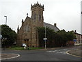
St John's Presbyterian Church, Beach Road, South Shields
Image: © Bill Henderson
Taken: 11 Jun 2012
0.12 miles
7
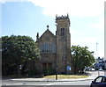
St John's Presbyterian Church, South Shields
Image: © JThomas
Taken: 7 Jul 2018
0.12 miles
8
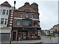
A building on the corner of Fowler Street, South Shields
My wife, who stands outside, worked one of her very first jobs here when this building was a shoe shop, around 35 years ago or so. Her Nana also cleaned here (one of her three cleaning jobs!) That's roots that is.
Image: © Jeremy Bolwell
Taken: 30 Jul 2021
0.13 miles
9
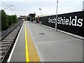
South Shields Metro station, Tyne & Wear
Opened in 2019 by the Tyne & Wear Metro as the terminus of the line from Pelaw and Newcastle, this station with bus interchange replaced a 1984 Metro station in the distance.
View north towards the end of the line.
Image: © Nigel Thompson
Taken: 28 Aug 2019
0.14 miles
10
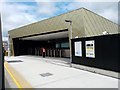
Metro Platform - Transport Interchange, South Shields
The £21m bus and Metro interchange opened to passengers on the 4th of August 2019. It is located about 100 metres from the old Metro Station. The old Metro station on King Street closed on the 8th of July 2019, in preparation for the opening of this new Transport Interchange which brought the Metro and bus services together under one roof. The old Metro station opened in 1984 and was the first station on the Tyne and Wear Metro to be permanently closed. In its 35 years of service the station had been used by over 50 million passengers, including tens of thousands or Great North Run athletes and spectators. The station had also featured in a song by pop group Franz Ferdinand. See: https://co-curate.ncl.ac.uk/south-shields-metro-station/
Image: © Simon Cotterill
Taken: 15 Aug 2019
0.14 miles