IMAGES TAKEN NEAR TO
Brotherlee Road, NEWCASTLE UPON TYNE, NE3 2SJ
Introduction
This page details the photographs taken nearby to Brotherlee Road, NE3 2SJ by members of the Geograph project.
The Geograph project started in 2005 with the aim of publishing, organising and preserving representative images for every square kilometre of Great Britain, Ireland and the Isle of Man.

There are currently over 7.5m images from over14,400 individuals and you can help contribute to the project by visiting https://www.geograph.org.uk
Image Map
Images are licensed for reuse under creativecommons.org/licenses/by-sa/2.0
Notes
- Clicking on the map will re-center to the selected point.
- The higher the marker number, the further away the image location is from the centre of the postcode.
Image Listing (4 Images Found)
Images are licensed for reuse under creativecommons.org/licenses/by-sa/2.0
Image
Details
Distance
1
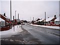
Road to North Fawdon
This photograph shows the road to North Fawdon after a recent fall of snow. The snow-laden road going off to the left in the foreground of the picture is Park Avenue. The picture was taken looking in a north-north-westerly direction towards Middle Brunton West Farm.
Image: © Philip Barker
Taken: 2 Jan 2010
0.03 miles
2
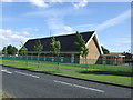
The Church Of Jesus Christ Of Latter Day Saints
On Hauxley Drive, Fawdon.
Image: © JThomas
Taken: 3 Aug 2013
0.14 miles
4
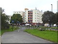
Ewart Court
Apartment block on Kingston Park Road. Pelican crossing in the foreground.
Image: © Oliver Dixon
Taken: 2 Sep 2019
0.21 miles