IMAGES TAKEN NEAR TO
Fawdon Park Road, NEWCASTLE UPON TYNE, NE3 2PP
Introduction
This page details the photographs taken nearby to Fawdon Park Road, NE3 2PP by members of the Geograph project.
The Geograph project started in 2005 with the aim of publishing, organising and preserving representative images for every square kilometre of Great Britain, Ireland and the Isle of Man.

There are currently over 7.5m images from over14,400 individuals and you can help contribute to the project by visiting https://www.geograph.org.uk
Image Map
Images are licensed for reuse under creativecommons.org/licenses/by-sa/2.0
Notes
- Clicking on the map will re-center to the selected point.
- The higher the marker number, the further away the image location is from the centre of the postcode.
Image Listing (6 Images Found)
Images are licensed for reuse under creativecommons.org/licenses/by-sa/2.0
Image
Details
Distance
2
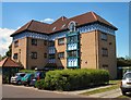
Maisonettes in Fawdon
There are several developments of this style in the same area.
Image: © Lis Burke
Taken: 25 Jun 2005
0.19 miles
4
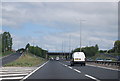
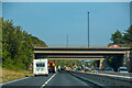
The A1 Western Bypass, Fawdon
Looking down onto the A1 from the grade separated junction above. Work is in progress to add an extra lane to each carriageway in an effort to increase the capacity of the road.
Image: © Graham Robson
Taken: 17 Jul 2022
0.21 miles
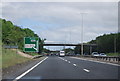
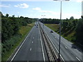
5
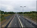
Gosforth : A1
Looking north along the A1.
Image: © Lewis Clarke
Taken: 21 Sep 2020
0.22 miles