IMAGES TAKEN NEAR TO
Tarset Place, NEWCASTLE UPON TYNE, NE3 2LT
Introduction
This page details the photographs taken nearby to Tarset Place, NE3 2LT by members of the Geograph project.
The Geograph project started in 2005 with the aim of publishing, organising and preserving representative images for every square kilometre of Great Britain, Ireland and the Isle of Man.

There are currently over 7.5m images from over14,400 individuals and you can help contribute to the project by visiting https://www.geograph.org.uk
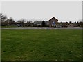
Image Map
Images are licensed for reuse under creativecommons.org/licenses/by-sa/2.0
Notes
- Clicking on the map will re-center to the selected point.
- The higher the marker number, the further away the image location is from the centre of the postcode.
Image Listing (24 Images Found)
Images are licensed for reuse under creativecommons.org/licenses/by-sa/2.0
Image
Details
Distance

2
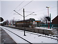
Wansbeck Road Metro station
This photograph shows a view of Wansbeck Road Metro station. The platform visible on the right-hand side of the railway is the one for south-bound trains coming from Newcastle airport.
Image: © Philip Barker
Taken: 2 Jan 2010
0.03 miles
3
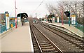
Wansbeck Road Metro station, Tyne & Wear
Opened by the Tyne & Wear Metro in 1980 on the line from Gosforth to (Newcastle) Airport.
View east towards Regent Centre and Gosforth.
Image: © Nigel Thompson
Taken: 23 Jan 2010
0.03 miles
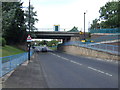
5
Metro bridge crossing Wansbeck Road, Gosforth
The Metro line between Regent Centre and Airport crosses Wansbeck Road ahead. A station, with a platform on either side of the bridge, takes its name from the road.
Image: © Graham Robson
Taken: 10 Feb 2018
0.08 miles
6
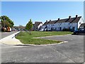
Park Avenue, Gosforth, Newcastle upon Tyne
A small patch of grass on Park Avenue with a line of young trees.
Image: © Graham Robson
Taken: 6 May 2020
0.10 miles
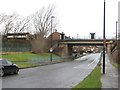
7
Wansbeck Road North
This was taken from the bridge of Wansbeck Road Metro station, looking north.
Image: © Lis Burke
Taken: 25 Jun 2005
0.11 miles
8
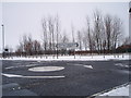
Mini-roundabout near golf course and playing fields
This photograph shows a mini-roundabout near the City of Newcastle Golf Course and playing fields which are located just to the north of the roundabout (behind the line of trees). The picture was taken just after a recent fall of snow in early January looking in a northerly direction towards the golf course.
Image: © Philip Barker
Taken: 2 Jan 2010
0.11 miles
9
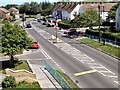
Shopping area, Wansbeck Road South
A variety of shops huddled together off Wansbeck Road South. The range of shops include a Co-Operative supermarket, chemist, takeaways and hairdressers.
Image: © Graham Robson
Taken: 10 Feb 2018
0.11 miles
10
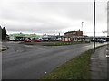
Regent Farm First School, Fawdon
The large first school in the Fawdon area of Newcastle.
Image: © Graham Robson
Taken: 10 Feb 2018
0.11 miles