IMAGES TAKEN NEAR TO
Lindisfarne Recess, JARROW, NE32 5UL
Introduction
This page details the photographs taken nearby to Lindisfarne Recess, NE32 5UL by members of the Geograph project.
The Geograph project started in 2005 with the aim of publishing, organising and preserving representative images for every square kilometre of Great Britain, Ireland and the Isle of Man.

There are currently over 7.5m images from over14,400 individuals and you can help contribute to the project by visiting https://www.geograph.org.uk
Image Map (Loading...)


Getting Data...Please wait
Leaflet Map data © OpenStreetMap
Images are licensed for reuse under creativecommons.org/licenses/by-sa/2.0
Notes
- Clicking on the map will re-center to the selected point.
- The higher the marker number, the further away the image location is from the centre of the postcode.
Image Listing (19 Images Found)
Images are licensed for reuse under creativecommons.org/licenses/by-sa/2.0
Image
Details
Distance
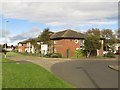
1
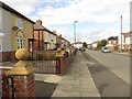
Naworth Terrace, Jarrow
A residential street in a quiet estate to the east of Jarrow town centre.
Image: © Graham Robson
Taken: 7 Oct 2017
0.09 miles
2
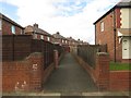
Path between gardens off Finchale Terrace, Jarrow
An alleyway between properties off Finchale Terrace.
Image: © Graham Robson
Taken: 7 Oct 2017
0.09 miles
3
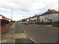
Finchale Terrace, Jarrow
A residential street in a housing estate to the east of Jarrow town centre.
Image: © Graham Robson
Taken: 7 Oct 2017
0.10 miles
4
Low Simonside Social Club in Jarrow
Low Simonside Social Club at Stanhope Road in Jarrow
It was demolished in 2006 and replaced by Needham Court Carehome
It was formerly called St. Mary's Catholic Club
Image: © Vin Mullen
Taken: 13 Jun 2003
0.15 miles
5
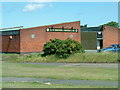
Care home, Stanhope Road, Jarrow
A care home at the end of Stanhope Road, in a quiet residential part of Jarrow.
Image: © Graham Robson
Taken: 7 Oct 2017
0.16 miles
6
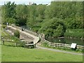
Primrose Local Nature Reserve
The Nature Reserve was created in 1990 by excavating a series of ponds and ditches where there had previously been amenity grassland. prone to occasional flooding. Planting them up resulted in a mosaic of marsh and open water habitats, which offers shelter and sustenance to a wide range of wetland wildlife.
Image: © Ken Brown
Taken: 6 Jun 2005
0.16 miles
8

Primrose Pit Stop, Great North Run
One of the best features along the 13.1 miles is the locally organised Primrose Pit Stop, just before we reach the A19 and the end of 8 miles.
In 2014 they did a YouTube video, see; https://www.youtube.com/watch?v=vvk7Ngir1NI
Image: © Chris Morgan
Taken: 11 Sep 2016
0.18 miles
9
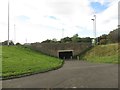
Subway under the A19, Jarrow
A subway under the busy A19 road which connects two residential areas.
Image: © Graham Robson
Taken: 7 Oct 2017
0.19 miles
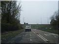
10

A19 ahead, and the fire brigade look for relief
Primrose pit stop is greatly appreciated as runners prepare to take the roundabout below the main road before the hard slog up John Reid Road towards the sea on the Great North Run.
Image: © Chris Morgan
Taken: 11 Sep 2016
0.19 miles