IMAGES TAKEN NEAR TO
Barns Close, JARROW, NE32 5NY
Introduction
This page details the photographs taken nearby to Barns Close, NE32 5NY by members of the Geograph project.
The Geograph project started in 2005 with the aim of publishing, organising and preserving representative images for every square kilometre of Great Britain, Ireland and the Isle of Man.

There are currently over 7.5m images from over14,400 individuals and you can help contribute to the project by visiting https://www.geograph.org.uk
Image Map
Images are licensed for reuse under creativecommons.org/licenses/by-sa/2.0
Notes
- Clicking on the map will re-center to the selected point.
- The higher the marker number, the further away the image location is from the centre of the postcode.
Image Listing (15 Images Found)
Images are licensed for reuse under creativecommons.org/licenses/by-sa/2.0
Image
Details
Distance
1
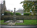
War Memorial
Sadly no wreaths laid yesterday. I can remember wreaths being placed here but I have no idea when this stopped.
Image: © Les Hull
Taken: 9 Nov 2009
0.02 miles
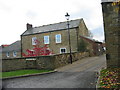
5
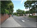
Speed cushions on Monkton Lane
By the junction with Cheviot Road.
Image: © Oliver Dixon
Taken: 14 Jul 2021
0.06 miles
8
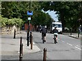
Cyclists on Monkton Lane
At Monkton Lane, the line of the Bowes Railway (National Cycle Network Regional Route 11) has been completely blocked at the southern end by vegetation and further north by Monkton Stadium. From here on, Route 11 is named the Monkton Cycleway.
Image: © Oliver Dixon
Taken: 14 Jul 2021
0.11 miles
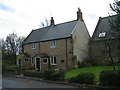
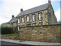
9
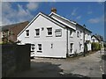
The White House
Care Home on Monkton Lane.
Image: © Oliver Dixon
Taken: 14 Jul 2021
0.14 miles
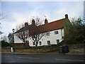
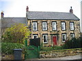
10
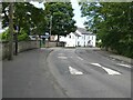
Speed cushions on Monkton Lane
At Monkton Lane, the line of the Bowes Railway (National Cycle Network Regional Route 11) has been completely blocked at the southern end by vegetation and further north by Monkton Stadium. From here on, Route 11 is named the Monkton Cycleway.
The White House Care Home can be seen on the bend.
Image: © Oliver Dixon
Taken: 14 Jul 2021
0.15 miles