IMAGES TAKEN NEAR TO
Falmouth Drive, JARROW, NE32 3SQ
Introduction
This page details the photographs taken nearby to Falmouth Drive, NE32 3SQ by members of the Geograph project.
The Geograph project started in 2005 with the aim of publishing, organising and preserving representative images for every square kilometre of Great Britain, Ireland and the Isle of Man.

There are currently over 7.5m images from over14,400 individuals and you can help contribute to the project by visiting https://www.geograph.org.uk
Image Map (Loading...)


Getting Data...Please wait
Leaflet Map data © OpenStreetMap
Images are licensed for reuse under creativecommons.org/licenses/by-sa/2.0
Notes
- Clicking on the map will re-center to the selected point.
- The higher the marker number, the further away the image location is from the centre of the postcode.
Image Listing (30 Images Found)
Images are licensed for reuse under creativecommons.org/licenses/by-sa/2.0
Image
Details
Distance
1
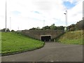
Subway under the A19, Jarrow
A subway under the busy A19 road which connects two residential areas.
Image: © Graham Robson
Taken: 7 Oct 2017
0.14 miles
2
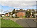
Care home, Stanhope Road, Jarrow
A care home at the end of Stanhope Road, in a quiet residential part of Jarrow.
Image: © Graham Robson
Taken: 7 Oct 2017
0.15 miles
3
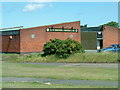
Low Simonside Social Club in Jarrow
Low Simonside Social Club at Stanhope Road in Jarrow
It was demolished in 2006 and replaced by Needham Court Carehome
It was formerly called St. Mary's Catholic Club
Image: © Vin Mullen
Taken: 13 Jun 2003
0.15 miles
4
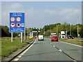
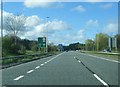
A19 approaching Tyne Tunnel
The Tyne Tunnel is the furthest downstream fixed crossing of the River Tyne and is part of the A19.
The original project consisted of a set of foot and cycle tunnels, opened in 1951, and a single carriageway road tunnel, which opened in 1967. The tunnel became a severe bottleneck during the 1980s and 1990s, and, in 2004, it was decided to build a second parallel tunnel. Construction started in 2008 and opened in early 2011. Traffic started using both tunnels and hence the route became dual carriageway in late 2011 (https://www.sabre-roads.org.uk/wiki/index.php?title=Tyne_Tunnel SABRE).
Image: © David Dixon
Taken: 29 Apr 2019
0.15 miles
6
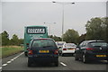
Queuing traffic on the A19
The traffic is stacking back from the roadworks at the Tyne Tunnel.
Image: © Bill Boaden
Taken: 16 Sep 2011
0.15 miles
7
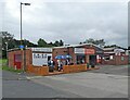
Tams Bar
A handy pre-match drinking spot for supporters of South Shields FC.
Image: © Roger Cornfoot
Taken: 25 Sep 2021
0.21 miles
8
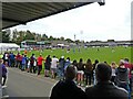
Warrington take a free kick
This Northern Premier League fixture ended South Shields 3 Warrington Town 2.
Image: © Roger Cornfoot
Taken: 25 Sep 2021
0.22 miles
9
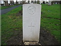
Commonwealth War Grave in Jarrow Cemetery (WW2-11)
Alexander Bryce.
Viewed on picture looking West.
http://www.cwgc.org/
Image: © Vin Mullen
Taken: 26 Jan 2007
0.22 miles
10
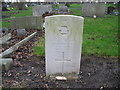
Commonwealth War Grave in Jarrow Cemetery (WW2-02)
Robert Harry Archer.
Viewed on picture looking West.
http://www.cwgc.org/
Image: © Vin Mullen
Taken: 26 Jan 2007
0.23 miles