IMAGES TAKEN NEAR TO
Ravel Court, JARROW, NE32 3BW
Introduction
This page details the photographs taken nearby to Ravel Court, NE32 3BW by members of the Geograph project.
The Geograph project started in 2005 with the aim of publishing, organising and preserving representative images for every square kilometre of Great Britain, Ireland and the Isle of Man.

There are currently over 7.5m images from over14,400 individuals and you can help contribute to the project by visiting https://www.geograph.org.uk
Image Map (Loading...)


Getting Data...Please wait
Leaflet Map data © OpenStreetMap
Images are licensed for reuse under creativecommons.org/licenses/by-sa/2.0
Notes
- Clicking on the map will re-center to the selected point.
- The higher the marker number, the further away the image location is from the centre of the postcode.
Image Listing (92 Images Found)
Images are licensed for reuse under creativecommons.org/licenses/by-sa/2.0
Image
Details
Distance
1
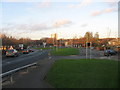
Howard Street in Jarrow
Howard Street in Jarrow.
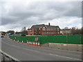
New road construction (A185)
Centre on picture is St. Bede's RC Primary School.
Right off centre on the picture the terraced houses are in Harold Street.
On the skyline the highrise flats are Wilkinson Court and Ellen Court.
Image: © Vin Mullen
Taken: 4 Apr 2009
0.04 miles
2
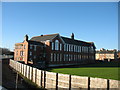
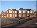
St. Bede's RC Primary School in Jarrow
St. Bede's RC Primary School in Harold Street in Jarrow
Photo taken from Howard Street
Image: © Vin Mullen
Taken: 18 Jan 2010
0.06 miles
3
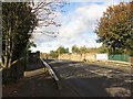
Monkton Terrace in Jarrow
Monkton Terrace in Jarrow.
Viewed from the railway bridge.
In the distance the highrise flats Wilkinson Court and Monastery Court
Image: © Vin Mullen
Taken: 27 Nov 2009
0.06 miles
4
St. Bede's RC Primary School in Jarrow
St. Bede's RC Primary School in Harold Street in Jarrow
Image: © Vin Mullen
Taken: 18 Jan 2008
0.07 miles
5

Howard Street in Jarrow
Howard Street in Jarrow.
New road construction (A185)
Right on picture is St. Bede's RC Primary School
Image: © Vin Mullen
Taken: 26 Nov 2009
0.07 miles
6
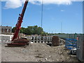
Construction of New Road Bridge
Construction of New Road Bridge seen from Howard Street in Jarrow
Image: © Vin Mullen
Taken: 11 Jul 2009
0.07 miles
7
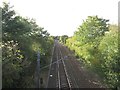
Railway lines east of Jarrow Metro Station
Looking along the railway tracks from the bridge which carries Monkton Terrace over the lines. The line on the left is used by Tyne and Wear Metro trains going to and from South Shields, the line on the right is used by freight trains accessing the sidings of the nearby oil terminal.
Image: © Graham Robson
Taken: 7 Oct 2017
0.08 miles
8
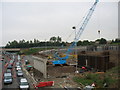
Construction of New Flyover
Construction of New Flyover seen from Howard Street in Jarrow.
Image: © Vin Mullen
Taken: 3 Jul 2009
0.08 miles
9
Bridge over the Metro lines, Monkton Terrace, Jarrow
Looking across the relatively narrow bridge which carries Monkton Terrace over the tracks of the Tyne and Wear Metro which pass below.
Image: © Graham Robson
Taken: 7 Oct 2017
0.08 miles