IMAGES TAKEN NEAR TO
Stanley Street, JARROW, NE32 3BD
Introduction
This page details the photographs taken nearby to Stanley Street, NE32 3BD by members of the Geograph project.
The Geograph project started in 2005 with the aim of publishing, organising and preserving representative images for every square kilometre of Great Britain, Ireland and the Isle of Man.

There are currently over 7.5m images from over14,400 individuals and you can help contribute to the project by visiting https://www.geograph.org.uk
Image Map (Loading...)


Getting Data...Please wait
Leaflet Map data © OpenStreetMap
Images are licensed for reuse under creativecommons.org/licenses/by-sa/2.0
Notes
- Clicking on the map will re-center to the selected point.
- The higher the marker number, the further away the image location is from the centre of the postcode.
Image Listing (126 Images Found)
Images are licensed for reuse under creativecommons.org/licenses/by-sa/2.0
Image
Details
Distance
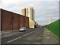
1
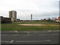
Before the start of TT2 in Jarrow
Just before the commencement of the New Tyne Tunnel (TT2) in Jarrow.
Image: © Vin Mullen
Taken: 25 Jan 2008
0.02 miles
2
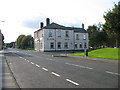
High Street in Jarrow
High Street in Jarrow looking West.
Showing The Alexandra Hotel on the corner of High Street and Minster Parade.
In the distance on the far left on the picture is St. Bede's RC Church on Monkton Road.
To the left of centre on the picture is the takeaways on Staple Road
Image: © Vin Mullen
Taken: 2 Oct 2008
0.04 miles
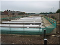
3
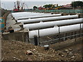
Tyne Crossing Trench
Trench running alongside Staple Road in Jarrow for the New Tyne Crossing.
Image: © Vin Mullen
Taken: 3 Jul 2009
0.04 miles
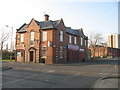
4
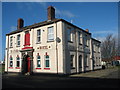
The Alexandra Hotel in Jarrow
The Alexandra Hotel on the corner of High Street/Minster Parade (formerly Princess Street) in Jarrow. Its original name was The Alexandra Hotel, then it was renamed O'Malley's Irish Bar before reverting back to its original name - The Alexandra Hotel.
Image: © Vin Mullen
Taken: 1 Feb 2008
0.05 miles
5
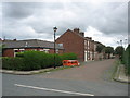
Staple Road in Jarrow
Staple Road looking North in Jarrow.
On the left of the picture is Jarrow Community Centre.
Centre is the Royal Oak public House ('Longbar')
Behind is Monastery Court High rise flats.
And to the right of the picture is the ventilation shaft off the Tyne Tunnel.
The fence contains the construction site of the new Tyne Tunnel
Image: © Vin Mullen
Taken: 26 Dec 2008
0.05 miles
6
Tyne Crossing Trench
Trench running alongside Stothard Street Jarrow to the east and Dee Street Jarrow to the west for the New Tyne Crossing.
Image: © Vin Mullen
Taken: 3 Jul 2009
0.05 miles
7
Takeaways in Jarrow
Two Takeaways and an Off Licence on the corner of High Street and Staple Road in Jarrow
Until the mid 1960s the whole building was a pork butchers called Abel who were of German descent
They were one of a number of German butchers in Jarrow from the turn of the 19th century
(The shop is on the 1901 census)
To the far left of the picture you can see Christ Church spire in the distance
To the right is the Jarrow Community Centre and behind that is Monastery Court Highrise Flats
Directly behind the shop (not seen) is Morrison's (Supermarket) car park
Image: © Vin Mullen
Taken: 18 Jan 2008
0.06 miles
8
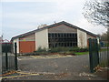
Dunn Street JMI & Nursery School in Jarrow
Dunn Street JMI & Nursery School in Minster Parade Jarrow
Image: © Vin Mullen
Taken: 30 Oct 2009
0.06 miles
9
Stothard Street Jarrow
Stothard Street in Jarrow
Image: © Vin Mullen
Taken: 12 Jul 2009
0.06 miles
10
Salem Street Jarrow
Salem Street East in Jarrow
Image: © Vin Mullen
Taken: 12 Jul 2009
0.07 miles