IMAGES TAKEN NEAR TO
Percy Villas, Lovaine Row, NORTH SHIELDS, NE30 4HE
Introduction
This page details the photographs taken nearby to Percy Villas, Lovaine Row, NE30 4HE by members of the Geograph project.
The Geograph project started in 2005 with the aim of publishing, organising and preserving representative images for every square kilometre of Great Britain, Ireland and the Isle of Man.

There are currently over 7.5m images from over14,400 individuals and you can help contribute to the project by visiting https://www.geograph.org.uk
Image Map
Images are licensed for reuse under creativecommons.org/licenses/by-sa/2.0
Notes
- Clicking on the map will re-center to the selected point.
- The higher the marker number, the further away the image location is from the centre of the postcode.
Image Listing (429 Images Found)
Images are licensed for reuse under creativecommons.org/licenses/by-sa/2.0
Image
Details
Distance
2
Sun Terrace above Short Sands, Tynemouth
Although still in March, with temperatures hitting the twenties locals took the opportunity of sitting out on this suntrap.
Image: © Oliver Dixon
Taken: 28 Mar 2012
0.04 miles
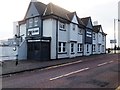
3
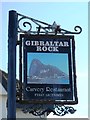
Sign for The Gibraltar Rock, East Street, NE30
See Image
Image: © Mike Quinn
Taken: 5 Aug 2014
0.05 miles
5
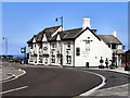
Gibraltar Rock
The Gibraltar Rock public house on East Street at Tynemouth.
Image: © David Dixon
Taken: 20 Jun 2011
0.05 miles
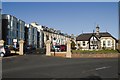
7
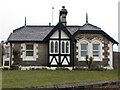
The Lodge, Percy Gardens, Tynemouth
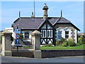
In the mid 19th century Tynemouth was growing in popularity as a commuter village following the opening of the railway link to Newcastle. Seizing upon the opportunity, the then Duke of Northumberland put forward plans for a substantial residential housing development on his land on the north and east edge of the village. The sweeping crescent of Percy Gardens with its grand houses https://www.geograph.org.uk/photo/6768929, private gated road, railed communal gardens commanding magnificent views of King Edward's Bay and Tynemouth Priory and Castle was the exclusive showpiece of this development. Plots were leased to individuals who employed their own architects and built their own houses in ones, twos and sometimes in fours in a restrained Victorian style achieving an attractive degree of architectural harmony. Most were built during the 1870s. A gardener was hired to look after the communal gardens and he was given his own lodge, seen here. For a selection of detailed free to download walking routes in the area visit www.northtynesidewalks.co.uk
Image: © Geoff Holland
Taken: 2 Mar 2021
0.06 miles
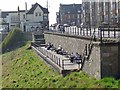
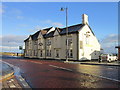
10
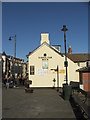
Gibraltar Rock Public House
Situated on the main road with a wonderful backdrop of the short sands and sea beyond!
Image: © Christine Westerback
Taken: 19 Feb 2012
0.06 miles