
IMAGES TAKEN NEAR TO
Winslow Court, NORTH SHIELDS, NE30 4AE
Introduction
This page details the photographs taken nearby to Winslow Court, NE30 4AE by members of the Geograph project.
The Geograph project started in 2005 with the aim of publishing, organising and preserving representative images for every square kilometre of Great Britain, Ireland and the Isle of Man.

There are currently over 7.5m images from over14,400 individuals and you can help contribute to the project by visiting https://www.geograph.org.uk
Image Map
Images are licensed for reuse under creativecommons.org/licenses/by-sa/2.0
Notes
- Clicking on the map will re-center to the selected point.
- The higher the marker number, the further away the image location is from the centre of the postcode.
Image Listing (236 Images Found)
Images are licensed for reuse under creativecommons.org/licenses/by-sa/2.0
Image
Details
Distance
1
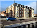
Winslow Court, Front Street, Cullercoats
The former Hudleston Arms Hotel where the American artist, Winslow Homer (1836-1910), first lodged when he stayed in Cullercoats from April 1881 to November 1882.
Image: © Andrew Curtis
Taken: 20 Nov 2015
0.01 miles

3
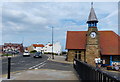
Cullercoats Fisherman's Lookout
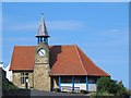
Built in 1879 on the site of a traditional fisherman's lookout, to house the Cullercoats Volunteer Life Brigade. A pre-existing clock tower was incorporated in the design. Now used as a community centre.
Image: © Mat Fascione
Taken: 5 Aug 2018
0.02 miles
6
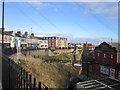
Cullercoats Crescent Club
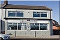
A CIU affiliated club established in 1947.
Image: © Mark Anderson
Taken: 27 Oct 2019
0.02 miles
8
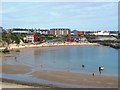
National Cycle Route 1 Victoria Crescent, Cullercoats
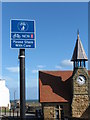
National Cycle Route 1 is part of the National Cycle Network, and is a 2,769 km-long cycle-path running from Dover to Shetland. As it passes through North Tyneside it hugs, as best it can, the North Sea coastline. At this point, it is also part of the England Coast Path which, when fully completed, will be the longest waymarked and managed coastal path in the world. In the background is the 1879-opened Watch House see https://www.geograph.org.uk/photo/1635130 for further details. For a selection of detailed free to download walking routes in the area visit www.northtynesidewalks.co.uk
Image: © Geoff Holland
Taken: 12 Mar 2020
0.02 miles
9
Waggonways Interpretation Board, Cullercoats
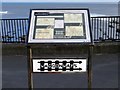
Coal was mined locally and transported to Cullercoats Bay on horse-drawn waggonways from around 1626. The coal was used for heating salt pans at Cullercoats and some exported. Cullercoats colliery closed in 1723, followed by Whitley Colliery the following year.
The route of the 'lost' waggonway was researched by children from Rockcliffe First School, Cullercoats in 2007. Working with North Tyneside Council, they placed waymarking studs along the route and provided designs for three waggonways interpretation panels.
http://www.waggonways.co.uk/
Image: © Andrew Curtis
Taken: 20 Nov 2015
0.02 miles
10
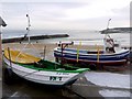
'James Denyer' coble fishing boat, Cullercoats
'James Denyer' was built in Amble in 1969. The 'SN 7' shows registration at North Shields Image
The fishing boat behind is the 10m 'Laura Jane II' registered in Chester. On 8th August 2007 the Tynemouth All Weather Lifeboat was launched to the Laura Jane II which had been fishing in an area known as the Playground south of the Tyne piers, when it sprang a leak. Its engine became swamped, but the skipper closed the sea cocks, stopping the leak. Cullercoats lifeboat had also been launched and as the Laura Jane II had earlier sailed from there it was decided that Cullercoats lifeboat would tow her back to safety http://www.tynemouth-lifeboat.org/
Image: © Andrew Curtis
Taken: 26 Dec 2009
0.03 miles