IMAGES TAKEN NEAR TO
Abbots Way, NORTH SHIELDS, NE29 8LX
Introduction
This page details the photographs taken nearby to Abbots Way, NE29 8LX by members of the Geograph project.
The Geograph project started in 2005 with the aim of publishing, organising and preserving representative images for every square kilometre of Great Britain, Ireland and the Isle of Man.

There are currently over 7.5m images from over14,400 individuals and you can help contribute to the project by visiting https://www.geograph.org.uk
Image Map (Loading...)


Getting Data...Please wait
Leaflet Map data © OpenStreetMap
Images are licensed for reuse under creativecommons.org/licenses/by-sa/2.0
Notes
- Clicking on the map will re-center to the selected point.
- The higher the marker number, the further away the image location is from the centre of the postcode.
Image Listing (13 Images Found)
Images are licensed for reuse under creativecommons.org/licenses/by-sa/2.0
Image
Details
Distance
1
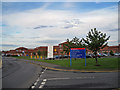
North Tyneside General Hospital, perimeter road
Looking towards the hospital from a part of its perimeter road. The large district general hospital in Rake Lane, North Shields, was built between 1984 and 1996. (The hospital itself stands in the adjacent grid square - Image).
Image: © Richard Dorrell
Taken: 2 Aug 2011
0.11 miles
3
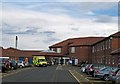
North Tyneside General Hospital - main entrance
A large modern hospital, built between 1984 and 1996, located just off Rake Lane in North Shields.
Image: © Richard Dorrell
Taken: 2 Aug 2011
0.14 miles
4
Whitehouse Lane
In the suburbs of North Shields.
Image: © Oliver Dixon
Taken: 5 Aug 2016
0.15 miles
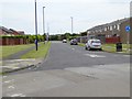
5
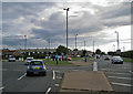
Rake Lane
The road is the A191. Junctions along this stretch, close to the Rake Lane North Shields General Hospital, are all roundabouts.
Image: © Richard Dorrell
Taken: 2 Aug 2011
0.15 miles
6
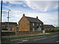
Rake House Farm
Located in Rake Lane, North Shields. The original stone farm buildings have been converted to provide modern open plan office accommodation. When photographed by Microkomputer in 2005, the buildings were completely derelict (see Image]).
Image: © Richard Dorrell
Taken: 2 Aug 2011
0.16 miles
7
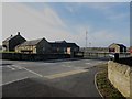
Rake House Farm
The stone buildings of a former farm steading have been converted into office accommodation.
Image: © Graham Robson
Taken: 24 Feb 2018
0.16 miles
9
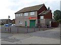
"Perfect" Chinese Takeaway
On Whitehouse Lane. All shuttered up and looking rather forlorn during daytime, but highly rated by customers..
Image: © Oliver Dixon
Taken: 5 Aug 2016
0.18 miles
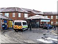
10
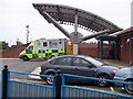
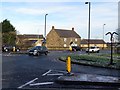
Ambulance on station at North Tyneside General Hospital
I found a 'legal' parking space, why couldn't the driver of the car in the foreground?
Image: © David Clark
Taken: 25 Jul 2012
0.19 miles