IMAGES TAKEN NEAR TO
Netherton Grove, NORTH SHIELDS, NE29 8JL
Introduction
This page details the photographs taken nearby to Netherton Grove, NE29 8JL by members of the Geograph project.
The Geograph project started in 2005 with the aim of publishing, organising and preserving representative images for every square kilometre of Great Britain, Ireland and the Isle of Man.

There are currently over 7.5m images from over14,400 individuals and you can help contribute to the project by visiting https://www.geograph.org.uk
Image Map (Loading...)


Getting Data...Please wait
Leaflet Map data © OpenStreetMap
Images are licensed for reuse under creativecommons.org/licenses/by-sa/2.0
Notes
- Clicking on the map will re-center to the selected point.
- The higher the marker number, the further away the image location is from the centre of the postcode.
Image Listing (11 Images Found)
Images are licensed for reuse under creativecommons.org/licenses/by-sa/2.0
Image
Details
Distance
1
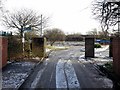
Derelict site off Morwick Road
Previously occupied by The Cedars Resource Centre, a residential care home. The two storey building was demolished and the site cleared at the end of 2017. There is another photo here Image
Image: © Andrew Curtis
Taken: 18 Jan 2018
0.06 miles
2
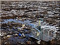
Soil & Trouble
Discarded supermarket trolley out of place on cleared and frozen land Image
"you might think that those trolleys you see out in carparks & under
sapling trees are sight-seeing. they aren’t.
they’re trying to avoid having things put in them."
From 'Shopping Trolleys', a poem by Jenny Boult, from Rattling in the Wind: Australian Poems for Children (1987).
Image: © Andrew Curtis
Taken: 18 Jan 2018
0.09 miles
3
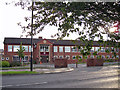
St Thomas More School, entrance
Established in 1988, the school faces the B1316, Billy Mill Lane. It is an 11-18 mixed comprehensive and specialist Maths and Computing school serving the Catholic population of North Tyneside. There are over 1700 pupils on roll, including more than 350 students post-16.
Image: © Richard Dorrell
Taken: 2 Aug 2011
0.21 miles
4
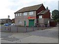
"Perfect" Chinese Takeaway
On Whitehouse Lane. All shuttered up and looking rather forlorn during daytime, but highly rated by customers..
Image: © Oliver Dixon
Taken: 5 Aug 2016
0.21 miles
5
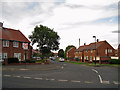
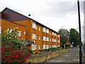
Cragside Avenue, Billy Mill
Residential road seen from its junction with the B1316 Billy Mill Lane.
Image: © Richard Dorrell
Taken: 2 Aug 2011
0.21 miles
6
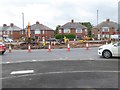
Roundabout reconstruction at Billy Mill
Roadworks on the busy Coast Road A1058, causing considerable disruption to traffic .
Image: © Oliver Dixon
Taken: 5 Aug 2016
0.22 miles
7
Whitehouse Lane
In the suburbs of North Shields.
Image: © Oliver Dixon
Taken: 5 Aug 2016
0.23 miles
8
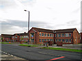
St Thomas More RC High School, Billy Mill
Established in 1988, the school faces the B1316, Billy Mill Lane. It is an 11-18 mixed comprehensive and specialist Maths and Computing school serving the Catholic population of North Tyneside. There are over 1700 pupils on roll, including more than 350 students post-16.
Image: © Richard Dorrell
Taken: 2 Aug 2011
0.24 miles
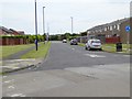
9
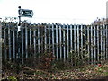
Public Footpath near Billy Mill, North Shields
This public footpath follows the western boundary of Preston Cemetery and leads to the A1058 (Coast Road). It also gives access to the adjacent Allotments. For a selection of detailed free to download walking routes in the area visit www.northtynesidewalks.co.uk
Image: © Geoff Holland
Taken: 16 Feb 2021
0.24 miles
10
St Aidan's House, Billy Mill
Located in Billy Mill Lane, St Aidan's House is a retirement home operated by Anchor Trust.
Image: © Richard Dorrell
Taken: 2 Aug 2011
0.24 miles