IMAGES TAKEN NEAR TO
Peebles Close, NORTH SHIELDS, NE29 8DN
Introduction
This page details the photographs taken nearby to Peebles Close, NE29 8DN by members of the Geograph project.
The Geograph project started in 2005 with the aim of publishing, organising and preserving representative images for every square kilometre of Great Britain, Ireland and the Isle of Man.

There are currently over 7.5m images from over14,400 individuals and you can help contribute to the project by visiting https://www.geograph.org.uk
Image Map
Images are licensed for reuse under creativecommons.org/licenses/by-sa/2.0
Notes
- Clicking on the map will re-center to the selected point.
- The higher the marker number, the further away the image location is from the centre of the postcode.
Image Listing (14 Images Found)
Images are licensed for reuse under creativecommons.org/licenses/by-sa/2.0
Image
Details
Distance
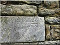
1
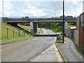
Underbridge on Westminster Avenue
Running south from New York, Westminster Avenue passes underneath the A191.
Image: © Oliver Dixon
Taken: 5 Aug 2016
0.06 miles
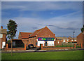
3
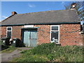
Old Forge (Smithy), Brookland Terrace, New York
It is thought that a forge has stood on this site since the mid-18th century. However, as this point was once an important medieval crossroads linking the monasteries of Lindisfarne and Jarrow, it is conceivable that a forge stood here long before the mid-18th century. When the first Ordnance Survey Six-Inch map of the area was published in 1865, the forge was not named on the map although the adjacent building was referred to as the 'Traveller's Rest (P.H.)'. When the 1898 Ordnance Survey map was published, the public house no longer existed and the only property shown and named on the map at this point was a 'Smithy'. This gives weight to the belief that the current brick building was built at some time between the publication of the two maps. For a selection of detailed free to download walking routes in the area visit www.northtynesidewalks.co.uk
Image: © Geoff Holland
Taken: 1 May 2020
0.15 miles
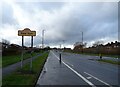
4
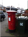
New York: postbox № NE29 59, New York Road
A large, George VI-reign postbox standing outside the post office.
Image: © Chris Downer
Taken: 7 Aug 2011
0.18 miles
6
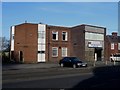
New York and Murton Social Club
A social club in the New York area of North Tyneside.
Image: © Graham Robson
Taken: 24 Feb 2018
0.20 miles
7
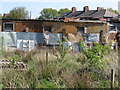
Stables, Murton Lane, New York
This is a rear view of the small stables which have their entrance on Murton Lane. The make do, patchwork boundary fence suggests that this is very much a low cost operation. For a selection of detailed free to download walking routes in the area visit www.northtynesidewalks.co.uk
Image: © Geoff Holland
Taken: 1 May 2020
0.22 miles
9
Quite a transformation!
Presumably built originally as a church, when this building was photographed by Bill Henderson in 2007, it was a Lighthouse Christian Centre (see Image). Today, with some alterations to the windows and doors, and doubtlessly to the interior, it serves as a local practice for Vets 4 Pets.
Image: © Richard Dorrell
Taken: 2 Aug 2011
0.23 miles
10
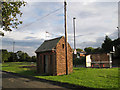
Mystery building
This small windowless building stands on a grass verge between Billy Mill Lane (in the background) and Barnstaple Road (in the foreground). It is fitted with a television-type aerial, and has a telegraph pole close to it, with a number of wires going off in various directions. I thought it may be a telephone exchange, but I am advised that this is unlikely. It would seem more probable that it has some purpose connected with the nearby underground reservoirs. Further suggestions gratefully received!
Update, Jan. 2021: I have received a message from a gentleman who lived locally to this little building. He tells me that he was taken into it on a school visit in the 1960s as a pupil at a nearby school. He says, "The building certainly has to do with the nearby reservoirs - or did have. It was full of meters and dials and those moving pen things that scratch lines on moving graph paper! All to do with the flowing of water at the nearby reservoirs - which I believe are now redundant as housing is being built over them!"
Apparently younger children called it "the fairies' house".
Image: © Richard Dorrell
Taken: 2 Aug 2011
0.23 miles