IMAGES TAKEN NEAR TO
High Flatworth, NORTH SHIELDS, NE29 7UT
Introduction
This page details the photographs taken nearby to High Flatworth, NE29 7UT by members of the Geograph project.
The Geograph project started in 2005 with the aim of publishing, organising and preserving representative images for every square kilometre of Great Britain, Ireland and the Isle of Man.

There are currently over 7.5m images from over14,400 individuals and you can help contribute to the project by visiting https://www.geograph.org.uk
Image Map (Loading...)


Getting Data...Please wait
Leaflet Map data © OpenStreetMap
Images are licensed for reuse under creativecommons.org/licenses/by-sa/2.0
Notes
- Clicking on the map will re-center to the selected point.
- The higher the marker number, the further away the image location is from the centre of the postcode.
Image Listing (17 Images Found)
Images are licensed for reuse under creativecommons.org/licenses/by-sa/2.0
Image
Details
Distance
1
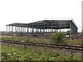
Industrial unit under construction, Tyne Tunnel Trading Estate
A new light industrial unit under construction on the Tyne Tunnel Trading Estate in North Tyneside.
Image: © Graham Robson
Taken: 1 May 2017
0.06 miles
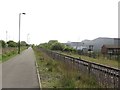
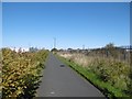
2
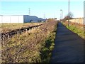
Backworth Colliery Railway
Trackbed of a mineral line, parallel to the North Tyneside Steam Railway, now a cycle/footpath.
Image: © Richard Webb
Taken: 1 Oct 2015
0.09 miles
3
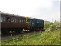
Train on the North Tyneside Steam Railway
A Class 08 diesel locomotive pulls a handful of vintage carriages along the volunteer run North Tyneside Steam Railway. The railway is based at the Stephenson Railway Museum.
Image: © Graham Robson
Taken: 1 May 2017
0.10 miles
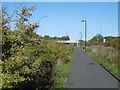
4
Footpath and adjacent railway line
Looking along a footpath which utilises a former waggonway with an adjacent heritage railway line which is operated by the Stephenson Railway Museum.
Image: © Graham Robson
Taken: 1 May 2017
0.13 miles
5
Cycle route on old railway at West Chirton
National Cycle Route 10, part of the Reiver's Cycle Route follows the line of the old Blyth and Tyne Railway and Seaton Burn Waggonway. The North Tyne Steam Railway, a heritage railway, runs alongside. The route here passes between trading estates on both sides.
Image: © Oliver Dixon
Taken: 4 Dec 2013
0.13 miles
6

Also for in-line skaters
Alternative use for the cycle path National Cycle Route 10, part of the Reiver's Cycle Route which follows the line of the old Blyth and Tyne Railway and Seaton Burn Waggonway. The bridge in the background carries the Coast Road.
Image: © Oliver Dixon
Taken: 4 Dec 2013
0.13 miles
7
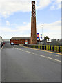
Tesco Chimney, West Chirton
The chimney is a well-known landmark in this area. It is the last remainder of the Ministry of Supply World War II munitions factory in the West Chirton area of North Shields. The chimney is a red brick design with the name Tesco now emblazoned on it in white paint (it is adjacent to the Tesco Extra North Shields store).
Image: © David Dixon
Taken: 20 Jun 2011
0.14 miles
8
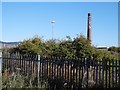
Mill chimney, West Chirton
Surviving chimney on what is now (obviously) a supermarket site.
Image: © Richard Webb
Taken: 1 Oct 2015
0.14 miles
9
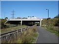
Bridge, A1058
A road bridge crossing the North Tyneside Steam Railway (Seatonburn Waggonway) and Backworth Colliery Railway. The mineral line is now a cycle path.
The railway is shown as operational on the 1981 1:50,000 Ordnance Survey map.
Image: © Richard Webb
Taken: 1 Oct 2015
0.16 miles
10
Backworth Colliery Railway
Now a cycle path. Behind the Japanese Knotweed on the left is the North Tyneside Steam Railway which uses the route of the Seatonburn Waggonway. On the right is an industrial area where at the time was awaiting redevelopment with the network of roads left after demolition of older units.
Image: © Richard Webb
Taken: 1 Oct 2015
0.16 miles