IMAGES TAKEN NEAR TO
Orion Way, NORTH SHIELDS, NE29 7SN
Introduction
This page details the photographs taken nearby to Orion Way, NE29 7SN by members of the Geograph project.
The Geograph project started in 2005 with the aim of publishing, organising and preserving representative images for every square kilometre of Great Britain, Ireland and the Isle of Man.

There are currently over 7.5m images from over14,400 individuals and you can help contribute to the project by visiting https://www.geograph.org.uk
Image Map
Images are licensed for reuse under creativecommons.org/licenses/by-sa/2.0
Notes
- Clicking on the map will re-center to the selected point.
- The higher the marker number, the further away the image location is from the centre of the postcode.
Image Listing (27 Images Found)
Images are licensed for reuse under creativecommons.org/licenses/by-sa/2.0
Image
Details
Distance
1
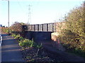
Railway Bridge
Bridge carrying the North Tyneside Steam Railway over the track bed of the former Cramlington Wagon Way.
Image: © Weston Beggard
Taken: 13 Nov 2005
0.09 miles
2
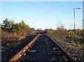
North Tyneside Steam Railway
North Tyneside Steam Railway Tracks
Image: © Weston Beggard
Taken: 13 Nov 2005
0.09 miles
3
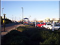
Car Showrooms on Silverlink
This part of the Silverlink Industrial/Trading estate seems to be a Mecca for car buyers.
Image: © Weston Beggard
Taken: 13 Nov 2005
0.09 miles
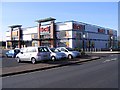
4
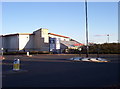
Silverlink Leisure
Cinema and restaurant on Silverlink estate
Image: © Weston Beggard
Taken: 13 Nov 2005
0.09 miles
5
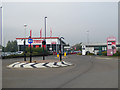
Vroom
A trading estate consisting entirely of car dealers and other motor related businesses on Orion Business Park in North Shields.
Image: © Oliver Dixon
Taken: 30 Sep 2015
0.11 miles
6
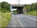
Restricted access at Bluehouse Bridges
The way out to the north from High Flatworth under the bridge carrying the Coast Road is restricted to bikes and buses. This means that the only exit from the Tyne Tunnel Trading Estate is to the south onto the A193.
Image: © Oliver Dixon
Taken: 5 Aug 2016
0.13 miles
7
Restricted access at Bluehouse Bridges
The way out to the north from High Flatworth under the bridge carrying the Coast Road is restricted to bikes and buses. This means that the only exit from the Tyne Tunnel Trading Estate is to the south onto the A193.
Image: © Oliver Dixon
Taken: 5 Aug 2016
0.14 miles
9
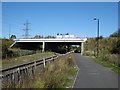
Bridge, A1058
A road bridge crossing the North Tyneside Steam Railway (Seatonburn Waggonway) and Backworth Colliery Railway. The mineral line is now a cycle path.
The railway is shown as operational on the 1981 1:50,000 Ordnance Survey map.
Image: © Richard Webb
Taken: 1 Oct 2015
0.16 miles
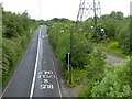
10
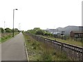
Footpath and adjacent railway line
Looking along a footpath which utilises a former waggonway with an adjacent heritage railway line which is operated by the Stephenson Railway Museum.
Image: © Graham Robson
Taken: 1 May 2017
0.17 miles