IMAGES TAKEN NEAR TO
Norham Road, NORTH SHIELDS, NE29 7AR
Introduction
This page details the photographs taken nearby to Norham Road, NE29 7AR by members of the Geograph project.
The Geograph project started in 2005 with the aim of publishing, organising and preserving representative images for every square kilometre of Great Britain, Ireland and the Isle of Man.

There are currently over 7.5m images from over14,400 individuals and you can help contribute to the project by visiting https://www.geograph.org.uk
Image Map (Loading...)


Getting Data...Please wait
Leaflet Map data © OpenStreetMap
Images are licensed for reuse under creativecommons.org/licenses/by-sa/2.0
Notes
- Clicking on the map will re-center to the selected point.
- The higher the marker number, the further away the image location is from the centre of the postcode.
Image Listing (13 Images Found)
Images are licensed for reuse under creativecommons.org/licenses/by-sa/2.0
Image
Details
Distance
1
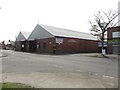
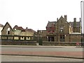
Bus Depot, Percy Main
A large site on Norham Road operated as a bus depot by Go North East.
Image: © Graham Robson
Taken: 1 May 2017
0.02 miles
2
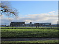
The Norham High School
Taken from Norham Road.
Image: © Ian S
Taken: 2 Feb 2013
0.11 miles
3
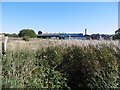
Undeveloped land, West Chirton
An industrial area beside the North Tyneside Steam Railway and cycle path.
Image: © Richard Webb
Taken: 1 Oct 2015
0.14 miles
4
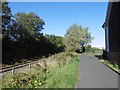
Path and North Tyneside Steam Railway
A preserved railway on the site of the Seatonburn Waggonway and the Blyth and Tyne Railway. There were two railways running beside each other here and one (Backworth Colliery railway) has been converted into the path used by the Reiver's Route. This is a coast to coast route through Kielder Forest.
The railway is shown as operational on the 1976 1:50,000 Ordnance Survey map.
Image: © Richard Webb
Taken: 1 Oct 2015
0.14 miles
5
Public House, Percy Main
The Redburn is a public house in Percy Main.
Image: © Graham Robson
Taken: 1 May 2017
0.16 miles
6
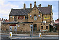
The Redburn
The Redburn public house in Percy Main.
Image: © Peter McDermott
Taken: 21 May 2011
0.16 miles
7
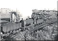
Class J27 65855, with a load of coal for the Tyne staithes
Image: © Roger Cornfoot
Taken: Unknown
0.19 miles
8
Waggonway conversion
A cycle/footpath using the former Backworth Colliery mineral line by West Chirton. The parallel railway is now a preserved line.
Image: © Richard Webb
Taken: 1 Oct 2015
0.19 miles
9
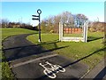
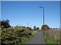
Cycleway at Percy Main
National Cycle Route 10, part of the Reiver's Cycle Route follows the line of the old Blyth and Tyne Railway and Seaton Burn Waggonway. The route diverges slightly from the line of the railway at this point to cross Burdon Street.
Image: © Oliver Dixon
Taken: 4 Dec 2013
0.20 miles
10
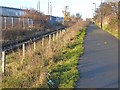
Cycle route on old railway at Percy Main
National Cycle Route 10, part of the Reiver's Cycle Route follows the line of the old Blyth and Tyne Railway and Seaton Burn Waggonway. The North Tyne Steam Railway, a heritage railway, runs alongside.
Image: © Oliver Dixon
Taken: 4 Dec 2013
0.20 miles