IMAGES TAKEN NEAR TO
Coronation Street, NORTH SHIELDS, NE29 6LP
Introduction
This page details the photographs taken nearby to Coronation Street, NE29 6LP by members of the Geograph project.
The Geograph project started in 2005 with the aim of publishing, organising and preserving representative images for every square kilometre of Great Britain, Ireland and the Isle of Man.

There are currently over 7.5m images from over14,400 individuals and you can help contribute to the project by visiting https://www.geograph.org.uk
Image Map (Loading...)


Getting Data...Please wait
Leaflet Map data © OpenStreetMap
Images are licensed for reuse under creativecommons.org/licenses/by-sa/2.0
Notes
- Clicking on the map will re-center to the selected point.
- The higher the marker number, the further away the image location is from the centre of the postcode.
Image Listing (147 Images Found)
Images are licensed for reuse under creativecommons.org/licenses/by-sa/2.0
Image
Details
Distance
1
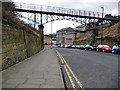
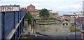
Looking down Borough Road towards the Tyne
Image: © Christine Johnstone
Taken: 4 Mar 2010
0.06 miles
2
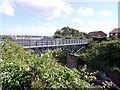
North Shields - Footbridge crossing Borough Road
Image: © Alan Heardman
Taken: 13 May 2008
0.06 miles
3
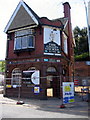
The Chain Locker Pub, North Shields
Sadly, only the shell of this once famous pub remains. There has been a pub on the site (opposite the entrance to the Ferry) since the early 19th century
Image: © Alan Fearon
Taken: 10 Jun 2005
0.06 miles
4
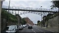
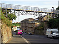
Footbridge, Borough Road
It crosses a street climbing hard away from the Tyne: rather graceful.
Image: © Richard Webb
Taken: 31 Jul 2012
0.06 miles
5
Footbridge, Borough Road, North Shields
Image: © Andrew Curtis
Taken: 28 Jul 2013
0.07 miles
6
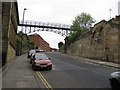
North Shields
Footbridge across Borough Road.
Image: © John Lucas
Taken: 15 Aug 2016
0.07 miles
7
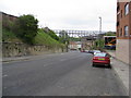
North Shields - Footbridge crossing road
Image: © Alan Heardman
Taken: 13 May 2008
0.07 miles
9
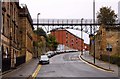
St Peter's Steps, Borough Road, North Shields
Cyclists are freewheeling down the steep bank of Borough Road below the footbridge Image heading for the Fish Quay or the Shields passenger ferry.
St Peter's Steps on the far side of the road provide access to Yeoman Street alongside remains of the former church and school. St Peter's Church (the Sailors' Church) was built to serve the Low Town on the corner of Borough Road and Clive Street in 1862 with funds provided by the Duke of Northumberland. The church was demolished in 1936.
http://www.tomorrows-history.com/public_item.php?collection=91&item=15083
Image: © Andrew Curtis
Taken: 28 Jul 2013
0.07 miles
10
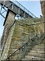
St. Peter's Stairs, Borough Road, North Shields
These stairs have been in existence since the latter part of the 19th century and gave access to St. Peter`s School and Yeoman Street. The bridge is an important link for pedestrians and cyclist from the adjoining banksides.
Image: © Geoff Holland
Taken: 27 Feb 2024
0.07 miles