IMAGES TAKEN NEAR TO
Borough Road, NORTH SHIELDS, NE29 6LH
Introduction
This page details the photographs taken nearby to Borough Road, NE29 6LH by members of the Geograph project.
The Geograph project started in 2005 with the aim of publishing, organising and preserving representative images for every square kilometre of Great Britain, Ireland and the Isle of Man.

There are currently over 7.5m images from over14,400 individuals and you can help contribute to the project by visiting https://www.geograph.org.uk
Image Map
Images are licensed for reuse under creativecommons.org/licenses/by-sa/2.0
Notes
- Clicking on the map will re-center to the selected point.
- The higher the marker number, the further away the image location is from the centre of the postcode.
Image Listing (187 Images Found)
Images are licensed for reuse under creativecommons.org/licenses/by-sa/2.0
Image
Details
Distance
1
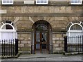
Old Custom House, Borough Road, North Shields
Built as Sailors' Home, still identified by lettering on the wall above the door. 1854-6 by Benjamin Green for 4th Duke of Northumberland. Now offices.
A Grade II Listed Building http://www.heritagegateway.org.uk/Gateway/Results_Single.aspx?resourceID=5&uid=1355018
Image: © Andrew Curtis
Taken: 28 Jul 2013
0.01 miles
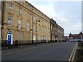
4
Collingwood Mansions, New Quay, North Shields
Image: © Andrew Curtis
Taken: 28 Jul 2013
0.02 miles
5
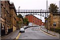
North Shields - Footbridge crossing road
Image: © Alan Heardman
Taken: 13 May 2008
0.02 miles
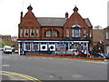
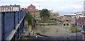
7
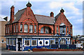
The Porthole
The Porthole public house on the Tyne.
Image: © Peter McDermott
Taken: 21 May 2011
0.02 miles
8
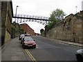
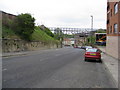
Footbridge over Borough Road, North Shields
A footbridge crosses Borough Road which is descending steeply to the banks of the River Tyne.
Image: © Graham Robson
Taken: 9 Oct 2016
0.02 miles
9
North Shields - Footbridge crossing Borough Road
Image: © Alan Heardman
Taken: 13 May 2008
0.02 miles
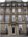
10
St Peter's Steps, Borough Road, North Shields
Cyclists are freewheeling down the steep bank of Borough Road below the footbridge Image heading for the Fish Quay or the Shields passenger ferry.
St Peter's Steps on the far side of the road provide access to Yeoman Street alongside remains of the former church and school. St Peter's Church (the Sailors' Church) was built to serve the Low Town on the corner of Borough Road and Clive Street in 1862 with funds provided by the Duke of Northumberland. The church was demolished in 1936.
http://www.tomorrows-history.com/public_item.php?collection=91&item=15083
Image: © Andrew Curtis
Taken: 28 Jul 2013
0.02 miles