IMAGES TAKEN NEAR TO
Duke Street, NORTH SHIELDS, NE29 6HB
Introduction
This page details the photographs taken nearby to Duke Street, NE29 6HB by members of the Geograph project.
The Geograph project started in 2005 with the aim of publishing, organising and preserving representative images for every square kilometre of Great Britain, Ireland and the Isle of Man.

There are currently over 7.5m images from over14,400 individuals and you can help contribute to the project by visiting https://www.geograph.org.uk
Image Map
Images are licensed for reuse under creativecommons.org/licenses/by-sa/2.0
Notes
- Clicking on the map will re-center to the selected point.
- The higher the marker number, the further away the image location is from the centre of the postcode.
Image Listing (158 Images Found)
Images are licensed for reuse under creativecommons.org/licenses/by-sa/2.0
Image
Details
Distance
1
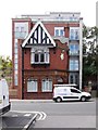
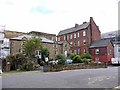
Former 'Chain Locker' Public House, North Shields
The 'Chain Locker' Public House was rebuilt in 1905 by Newcastle Breweries to a design by the firm of Joseph Oswald and Son Image The old building has been cleverly retained in a new apartment development by North Court Developments Ltd.
Image: © Andrew Curtis
Taken: 28 Jul 2013
0.00 miles
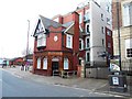
3
Apartments, New Quay, North Shields
A modern residential development incorporating a new build apartment block and a former pub, The Crane House Vaults, sitting on the road side.
Image: © Graham Robson
Taken: 9 Oct 2016
0.01 miles
4
Bus terminal for the Shields Ferry
At New Quay, North Shields.
Image: © John Lucas
Taken: 15 Aug 2016
0.01 miles
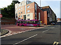
5
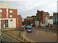
New Quay - Ferry Terminal bus terminus
A 333 service bus is loading passengers at the New Quay - Ferry Terminal bus terminus.
The bus terminus is near to the ferry terminal and provides a convenient connection for Shields Ferry passengers.
Image: © Adrian Taylor
Taken: 23 Jan 2008
0.01 miles
6
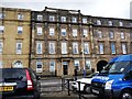
Collingwood Mansions, New Quay, North Shields
The eastern end of this building was, in 1854, the New Quay Sailors Home
Image: © Christine Johnstone
Taken: 4 Mar 2010
0.01 miles
7
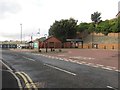
Bus turning area, New Quay, North Shields
A bus turning area and stops at the end of New Quay, North Shields, adjacent to the North Shields landing of the Shields Ferry.
Image: © Graham Robson
Taken: 9 Oct 2016
0.02 miles
8
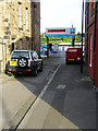
The entrance to the Shields Ferry at North Shields
A half-hourly service for pedestrians to South Shields.
Image: © John Lucas
Taken: 15 Aug 2016
0.02 miles
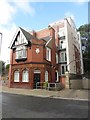
9
New Quay, North Shields
The red-brick building on the right, on the corner of Ferry Mews and Duke Street, was a commercial office building of c.1860-80. The ground floor was described as a waiting room for the nearby ferry in the 1895 Ordnance Survey. The building was converted to a tea room and shop ('Ye Olde Anchor Tea Shop') between 1960 and 1989.
http://www.pastscape.org.uk/hob.aspx?hob_id=955256 https://web.archive.org/web/20170222002055/http://www.pastscape.org.uk/hob.aspx?hob_id=955256
The stone-built building to the left was a warehouse built between 1800 and 1831 with a four-storey section on the riverside and a two-storey range on the street which is now a private house.
http://www.pastscape.org.uk/hob.aspx?hob_id=955292 https://web.archive.org/web/20170226001849/http://www.pastscape.org.uk/hob.aspx?hob_id=955292
Image: © Andrew Curtis
Taken: 28 Jul 2013
0.02 miles
10
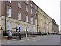
New Quay, North Shields
The central building in the terrace, built of pale sandstone in the Italianate style, is the former Northumberland Arms, a three-storey hotel, now offices. Begun in 1800 by D.Stephenson for the Duke of Northumberland.
Pastscape: http://www.pastscape.org.uk/hob.aspx?hob_id=955314 https://web.archive.org/web/20160511205532/https://www.pastscape.org.uk/hob.aspx?hob_id=955314
Image: © Andrew Curtis
Taken: 28 Jul 2013
0.03 miles