IMAGES TAKEN NEAR TO
Earl Grey Way, NORTH SHIELDS, NE29 6AR
Introduction
This page details the photographs taken nearby to Earl Grey Way, NE29 6AR by members of the Geograph project.
The Geograph project started in 2005 with the aim of publishing, organising and preserving representative images for every square kilometre of Great Britain, Ireland and the Isle of Man.

There are currently over 7.5m images from over14,400 individuals and you can help contribute to the project by visiting https://www.geograph.org.uk
Image Map (Loading...)


Getting Data...Please wait
Leaflet Map data © OpenStreetMap
Images are licensed for reuse under creativecommons.org/licenses/by-sa/2.0
Notes
- Clicking on the map will re-center to the selected point.
- The higher the marker number, the further away the image location is from the centre of the postcode.
Image Listing (48 Images Found)
Images are licensed for reuse under creativecommons.org/licenses/by-sa/2.0
Image
Details
Distance
1
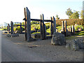
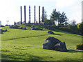
"Rugged Landscape", Redburn Dene
Originally one of the main rail corridors down to the coal staithes from the coalfields in Northumberland, the path through Redburn Dene park is now followed by National Cycle Network route 72, "Hadrians Cycleway".
The large timbers used to form the carved columns were reclaimed from the nearby redundant coal staithes and along with the large boulders form the "Rugged Landscape", one of the sights along the Royal Quays Art Walk.
Image: © Oliver Dixon
Taken: 30 Sep 2015
0.10 miles
2
"Rugged Landscape", Redburn Dene
Originally one of the main rail corridors down to the coal staithes from the coalfields in Northumberland, the path through Redburn Dene park is now followed by National Cycle Network route 72, "Hadrians Cycleway".
The large timbers used to form the carved columns were reclaimed from the nearby redundant coal staithes and along with the large boulders form the "Rugged Landscape", one of the sights along the Royal Quays Art Walk.
Image: © Oliver Dixon
Taken: 30 Sep 2015
0.10 miles
4
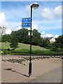
Sign, Redburn Dene, North Shields
Like its neighbour Chirton Dene, Redburn Dene follows the natural watercourse. When the Ordnance Survey Six-Inch map was published in 1895, this area formed part of Albert Edward Dock and was covered by a spider's web of waggonways. By the 1980s this area had largely become disused and derelict. The now disbanded Tyne & Wear Development Corporation were given the task of reclaiming the land, and, in partnership with North Tyneside Council and the private sector, created the Royal Quays development, an 80 hectare mix of housing, offices, and leisure facilities. As this sign indicates, a number of National Cycling Routes (NCR) pass through Redburn Dene. For a selection of detailed free to download walking routes in the area visit www.northtynesidewalks.co.uk
Image: © Geoff Holland
Taken: 2 Aug 2020
0.16 miles
5
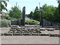
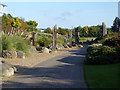
Entrance, Redburn Dene, North Shields
Like its neighbour Chirton Dene, Redburn Dene follows the natural watercourse. When the Ordnance Survey Six-Inch map was published in 1895, this area formed part of Albert Edward Dock and was covered by a spider's web of waggonways. By the 1980s this area had largely become disused and derelict. The now disbanded Tyne & Wear Development Corporation were given the task of reclaiming the land, and, in partnership with North Tyneside Council and the private sector, created the Royal Quays development, an 80 hectare mix of housing, offices, and leisure facilities. This is one of a number of entrances to the dene and is marked with large redundant wooden staithes. For a selection of detailed free to download walking routes in the area visit www.northtynesidewalks.co.uk
Image: © Geoff Holland
Taken: 2 Aug 2020
0.16 miles
7
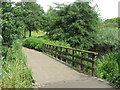
Bridge, Chirton Dene, North Shields
Like its neighbour Redburn Dene, Chirton Dene, which was created out of the former dock area in 1998, follows the natural watercourse. The dene has water as its central theme, and the aptly titled 'Water Landscape' first appears as a mountain stream, followed by reed beds, a central pool, a cadence and a boggy area, before culminating in a series of cascades which tumble down to the Albert Edward Dock. This bridge crosses part of the central pool with reed beds on either side. For a selection of detailed free to download walking routes in the area visit www.northtynesidewalks.co.uk
Image: © Geoff Holland
Taken: 9 Aug 2020
0.16 miles
9
The Henge, Redburn Dene
Wooden sculpture on top of a low hill in Redburn Dene park, one of the attractive features along the Royal Quays Art Walk. Within the henge is a map of the British Isles made of coloured pebbles.
Image: © Oliver Dixon
Taken: 30 Sep 2015
0.17 miles