IMAGES TAKEN NEAR TO
Tudor Avenue, NORTH SHIELDS, NE29 0RX
Introduction
This page details the photographs taken nearby to Tudor Avenue, NE29 0RX by members of the Geograph project.
The Geograph project started in 2005 with the aim of publishing, organising and preserving representative images for every square kilometre of Great Britain, Ireland and the Isle of Man.

There are currently over 7.5m images from over14,400 individuals and you can help contribute to the project by visiting https://www.geograph.org.uk
Image Map
Images are licensed for reuse under creativecommons.org/licenses/by-sa/2.0
Notes
- Clicking on the map will re-center to the selected point.
- The higher the marker number, the further away the image location is from the centre of the postcode.
Image Listing (24 Images Found)
Images are licensed for reuse under creativecommons.org/licenses/by-sa/2.0
Image
Details
Distance
1
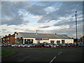
Alexandra Cars
Subaru and Daihatsu dealers located at the junction of Queen Alexandra Road West and Regency Gardens, North Shields.
Image: © Richard Dorrell
Taken: 2 Aug 2011
0.08 miles

6
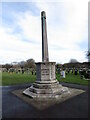
Preston Colliery War Memorial, Preston Cemetery, North Shields
This First World War Memorial, which is Grade II Listed, was designed by the firm of Cackett and Burns Dick of Newcastle who also designed the Laing Art Gallery, Newcastle upon Tyne https://www.geograph.org.uk/photo/1672772 and the Spanish City, Whitley Bay https://www.geograph.org.uk/photo/5943761. It was unveiled in June 1924 and commemorates the 65 men from Preston Colliery who lost their lives in the 1914-18 conflict. It was originally sited at the junction of Queen Alexandra Road and Billy Mill Lane, but was moved to its present location in 1964 due to road development. For a selection of detailed free to download walking routes in the area visit www.northtynesidewalks.co.uk
Image: © Geoff Holland
Taken: 16 Feb 2021
0.16 miles
7
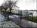
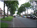
Recreation Ground off Heaton Terrace
The notice board on the right shows the start of the Preston Waggonway discovered by pupils at Collingwood Primary School in North Shields in 2005. Preston Waggonway carried coal from the small Preston pit, which used to lie roughly where the bowling club and Heaton Terrace are located today, to Tynemouth Gas Company works in North Shields. The gasholder in Minton Lane, at the end of the Waggonway Trail, was dismantled in 2009.
http://www.jimscott.co.uk/Local/LH_440_waggonways.html
Image: © Andrew Curtis
Taken: 18 Jan 2018
0.16 miles
9
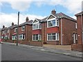
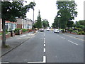
Semi-detached houses in Queen Alexandra Road West
Image: © Roger Cornfoot
Taken: 26 May 2015
0.17 miles
10
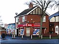
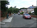
Verne Newsagents at junction of Heaton Terrace & Verne Road
The painted wall housing a ATM cash dispenser can be seen to the left of the shop Image
Image: © Andrew Curtis
Taken: 18 Jan 2018
0.17 miles