IMAGES TAKEN NEAR TO
Furrow Drive, WALLSEND, NE28 9FG
Introduction
This page details the photographs taken nearby to Furrow Drive, NE28 9FG by members of the Geograph project.
The Geograph project started in 2005 with the aim of publishing, organising and preserving representative images for every square kilometre of Great Britain, Ireland and the Isle of Man.

There are currently over 7.5m images from over14,400 individuals and you can help contribute to the project by visiting https://www.geograph.org.uk
Image Map
Images are licensed for reuse under creativecommons.org/licenses/by-sa/2.0
Notes
- Clicking on the map will re-center to the selected point.
- The higher the marker number, the further away the image location is from the centre of the postcode.
Image Listing (13 Images Found)
Images are licensed for reuse under creativecommons.org/licenses/by-sa/2.0
Image
Details
Distance
1
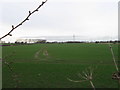
Farmland
N of Leicester Close and Sunholme Drive, Wallsend
Image: © Alex McGregor
Taken: 6 Apr 2010
0.05 miles
3
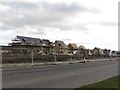
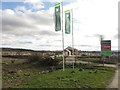
Houses under construction, East Benton Rise
Houses under construction on the side of Station Road. The homes are part of the East Benton Rise development by Persimmon.
Image: © Graham Robson
Taken: 19 Feb 2017
0.13 miles
4
East Benton Rise housing development
A large housing development by Persimmon Homes on the northern edge of Wallsend.
Image: © Graham Robson
Taken: 19 Feb 2017
0.16 miles
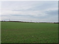
5
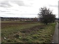
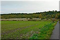
Fallow land, Benton
A fallow field on the edge of Benton and Wallsend. The field is uncropped as the adjacent land is in the process of having a new housing development built on it.
Image: © Graham Robson
Taken: 19 Feb 2017
0.18 miles
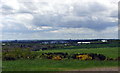
7
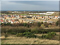
Housing Development near Rising Sun Country Park
This photograph was taken from the top of the former spoil heap of the Rising Sun Colliery and shows the extensive housing development between Station Road (A186) and Whitley Road (A191). Sunk in 1906, with production starting in 1908, the colliery was owned by Wallsend & Hebburn Coal Co. Ltd. In 1935 it was described as, "probably the most complete coal preparation plant in the world", providing dry-cleaning, wet-washing, wet and dry screening and blending and mixing and other processes for producing high quality product. The shaft eventually reached a depth of 769 ft (234 m) to exploit the Bensham coal seam, making it one of the deepest in Europe at the time. By 1965 there were 1,722 people employed at the colliery (1,442 working below ground, and 280 working on the surface). The colliery closed in 1969 and the buildings were demolished in the early 1970s. This is now the site of the Rising Sun Country Park which covers an area of 162 hectares, boasts a nature reserve with ponds, woodlands and extensive grasslands, a farm and Countryside Centre, and is criss-crossed by numerous paths and tracks. For a selection of detailed free to download walking routes in the area visit www.northtynesidewalks.co.uk
Image: © Geoff Holland
Taken: 24 Nov 2020
0.21 miles
8
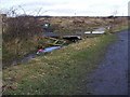
Rising Sun Country Park
This is the re-modelled shale heap on its more attractive side.
Image: © Mac McCarron
Taken: 15 Oct 2007
0.21 miles
9

Sparrowhawk
A regular visitor along with his mate. Many residents put out food for small birds and the sparrowhawks are only too pleased to take advantage.
Image: © Mac McCarron
Taken: 18 Oct 2008
0.22 miles