IMAGES TAKEN NEAR TO
Chicken Road, WALLSEND, NE28 8NN
Introduction
This page details the photographs taken nearby to Chicken Road, NE28 8NN by members of the Geograph project.
The Geograph project started in 2005 with the aim of publishing, organising and preserving representative images for every square kilometre of Great Britain, Ireland and the Isle of Man.

There are currently over 7.5m images from over14,400 individuals and you can help contribute to the project by visiting https://www.geograph.org.uk
Image Map (Loading...)


Getting Data...Please wait
Leaflet Map data © OpenStreetMap
Images are licensed for reuse under creativecommons.org/licenses/by-sa/2.0
Notes
- Clicking on the map will re-center to the selected point.
- The higher the marker number, the further away the image location is from the centre of the postcode.
Image Listing (16 Images Found)
Images are licensed for reuse under creativecommons.org/licenses/by-sa/2.0
Image
Details
Distance
4
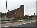
The R.C. Church of St Bernadette, Station Road, Wallsend
Image: © Bill Henderson
Taken: 11 Jun 2012
0.17 miles
5
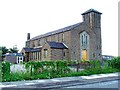
St. Bernadette Roman Catholic Church
Situated in the northern part of Wallsend
Image: © Christine Westerback
Taken: 14 Aug 2005
0.19 miles
6
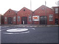
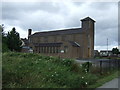
Disused Factory
Disused engineering works in Wallsend. The company is still a going concern - they have moved to new premises on the Silverlink Industrial Estate.
October 2006 Update : this building has now been demolished.
Image: © Weston Beggard
Taken: 13 Nov 2005
0.19 miles
7
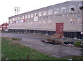
Disused Factory
Disused factory on the Coast Road. Offering a building in this condition for rental seems a touch optimistic, I have to say.
October 2006 update : this factory has now been demolished.
Image: © Weston Beggard
Taken: 13 Nov 2005
0.19 miles
8
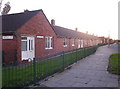
Selby Gardens
Old-folks' bungalows in Wallsend.
Image: © Weston Beggard
Taken: 13 Nov 2005
0.19 miles
9
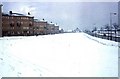
Wiltshire Gardens Maisonettes
A large area of the green in front of these flats was used to widen the A1058. The flats were knocked down within the last decade. Were the winters really worse then?
Image: © Christine Westerback
Taken: Unknown
0.19 miles
10
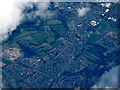
Wallsend from the air
Looking along the A1058 Coast Road from an Edinburgh bound flight from Prague.
Image: © Thomas Nugent
Taken: 18 Aug 2017
0.19 miles